The Nomads Outdoors Group Inc.
Powered by
Events
Upcoming
Sep
01
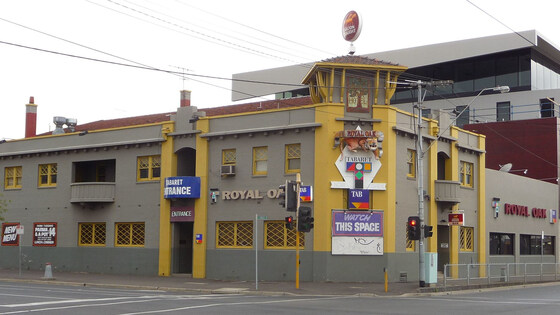
September Social Night - Royal Oak, Richmond
Royal Oak
19:00 – 21:00
Our regular monthly social night - this month at the Royal Oak, Richmond.
GRADE: Social.
ACTIVITY DESCRIPTION: The Nomads hold a social night each month, where members and guests can enjoy a meal, talk about upcoming events, compare notes on past activities and float ideas on events they would like to see run. Do you want to see more of a particular activity, or do you have a particularly favourite area of Victoria you would like to share with others? Do you have an idea for a walk we haven't done before? If so, we'd love to hear from you. Everyone is welcome – new members are especially invited to any of the monthly Nomads social evenings.
Tuesday nights are $20 Parma Nights - served with chips and salad. And there's a Seniors Menu for those who qualify. Check out the Royal Oak Menu.
BOOKING: By Sunday 30th August. To register, click on Get Tickets.
Unsure whether you've booked already? Click View my bookings.
MEETING TIME | LOCATION: 7pm on Tuesday 1st September at the Royal Oak, 527 Bridge Rd, Richmond.
MAP REFERENCE: Google map maps.app.goo.gl/9Khwm5nFWqB4Y93z9.
PUBLIC TRANSPORT: The tram stop of the #48 and #75 trams is right at the door.
LEADER: Alan D. | Email LeaderAlanD@nomads.org.au if you have any questions.
Members can access leader contact details under Members | Leader Contacts when logged in to the website.
HOME BACK TO LIST OF EVENTS MEMBERSHIPS
Sep
13
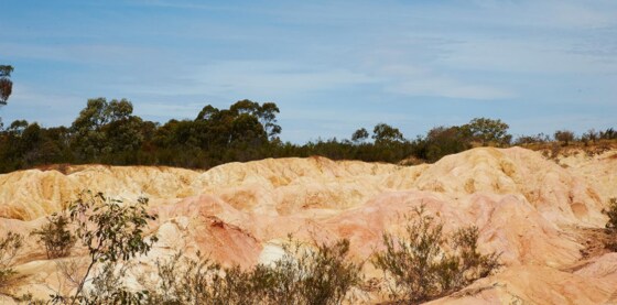
O'Keefe Rail Trail - Lake Eppalock to Heathcote walk
Heathcote
10:00 – 16:00
The last section of the O'Keefe Rail Trail from Lake Eppalock to Heathcote, visit the Pink Cliffs and a scenic lookout.
GRADE | LENGTH | TYPE: Moderate 12.6 km walk. Mostly flat on a gravel rail trail, plus a short uneven walk at the Pink Cliffs. (graded according to the AWTGS: Australian Walking Tracks Grading System).
ACTIVITY DESCRIPTION: After meeting in the car park, we carpool to the start of the walk at the O'keefe Rail Trail at Lake Eppalock. We walk along the lake for 1 km, depending on winter rainfall, will determine if the lake water reaches this point. We walk for about 2.5 hours along the rail trail through forest and farm land. After lunch we continue into Heathcote and visit the Pink Cliffs and then drive up to the Viewing Rock Lookout for views over Heathcote and surrounding countryside before returning to town for refreshments at the Commercial Hotel or a bakery before heading home.
BOOKING: By Friday 11th September. To register click on Get Tickets.
Unsure if you've already booked? Click View my bookings.
FURTHER INFORMATION: OKeefe Rail Trail | Commercial Hotel Heathcote |
MEETING TIME | LOCATION: 10.00am, Lions Club Picnic Shelter Car Park, Herriot Street at the rail trail.
MAP REFERENCE: Melway map X921 grid F10 | Google map https://maps.app.goo.gl/wVWD12GZX1SPocod9
DISTANCE | TIME FROM GPO: 130 km, aproximately 1 hr 40 min via Kilmore & Heathcote. Alternative routes via Lancefield 126 km, 1 hr 40 min or 141 km, 1 hour 40 minutes via Calder Fwy/M79 to Kynton, then follow C326 via Redesdale to Heathcote.
PUBLIC TRANSPORT: Not Available. If you need a lift or to carpool, contact leader at least a week in advance to arrange.
FOOD: Carry lunch, snacks, and 1 to 2 litres of water. After-walk refreshments at Gaffney's Bakery (closes 4pm) or at the Commercial Hotel.
APPAREL | FOOTWEAR: Comfortable walking boots/shoes and dress according to the weather forecast. Heathcote can be warmer and sunnier than Melbourne.
LEADER: Paul K. | Email LeaderPaulK@nomads.org.au if you have any questions.
Members can access leader contact details under Members | Leader Contacts when logged in to the website.
Image: Visit Victoria
HOME BACK TO LIST OF EVENTS MEMBERSHIPS
Oct
09
BWV FedWalks weekend - Great Southwest Walk
17 Julia St
09 Oct 2026 15:00 – 11 Oct 2026 16:00
Participation in the annual Federation Walks event is one of the benefits of our membership of Bushwalking Victoria. Bookings for the Federation Walks weekend based in Portland will open on 1 July 2026.
GRADE | LENGTH | TYPE: 20+ different walks are available. The walks are likely to range from Easy 2 km to Hard 18 km.
ACTIVITY DESCRIPTION: The FedWalks weekend happens in a different part of Victoria each year - this year it will be based in Portland to do sections of the Great South West Walk. Detailed maps and descriptions of all the walks on offer will be provided.
The Great South West Walk (GSWW) is a 250-kilometer, 12-to-15-day loop hiking trail beginning and ending in Portland, Victoria, offering a diverse, challenging journey through forests, along the Glenelg River, and across rugged coastlines. It's an epic showcase of the natural beauty of far west Victoria. Meander through tranquil forests of the Cobboboonee, enter the limestone gorge of the Glenelg River and the long, lonely coast of Discovery Bay. It winds through the diverse landscapes of Lower Glenelg National Park, Discovery Bay Coastal Park, Cobboboonee National Park and Cape Nelson State Park. Starting from the township of Portland in south west Victoria, the walk takes you on an unforgettable journey across rugged cliffs carved by the Southern Ocean, over remote beaches, past ancient, pristine lakes and through majestic, tall forest.
Memorable features include the highest sea cliffs in Victoria, blowholes, Petrified Forest, and seal colony at Cape Bridgwater, historic Cape Nelson Lighthouse, Princess Margaret Rose Caves, Aboriginal heritage places and the beautiful seaside village of Nelson, where the Glenelg River meets the sea. Along the way you’ll discover a diverse variety of plants and wildlife such as koalas, kangaroos, Blue and Southern Right Whales, and a huge variety of native birds, including the Australasian Gannet.
The walk is maintained through a partnership between volunteers from Friends of the Great South West Walk and Parks Victoria. Many thanks to those volunteers as well as to the volunteers taking on responsibility for organising this FedWalks program.
The Nomads has booked the 4-bedroom Roantree House, 17 Julia Street, Portland for Friday and Saturday nights at a total cost of $721.56. The accommodation cost will be divided equitably depending on how many people are staying in the house.
BOOKING: By 31 August, or ASAP to ensure you don't miss out! This event is only open to members of clubs affiliated with Bushwalking Victoria. Visitors should get a 1-month Temporary Membership prior to booking their tickets. Tickets are free to book - the leader will collect accommodation fees directly from the attendees. The steps for booking are:
Check out the BWV Walks Program to decide which walk(s) you would like to do.
Click the TryBooking link (once available) to select the walks you wish to do on Saturday, and on Sunday and also select the Saturday Night Dinner option if you wish, then pay the FedWalks Registration Fee.
Select Get Tickets on this Nomads events listing, so we know who is attending, to help with coordination.
IMPORTANT: You must book, select the FedWalks walks you wish to do, and pay per walk ASAP. A ticket with The Nomads is not sufficient to grant you access to the weekend!
Unsure if you've already booked with The Nomads? Click View my bookings.
FURTHER INFORMATION:
Summary of Walks: the link will be provided here as soon as it is available.
FedWalks website: Detailed information is available on fedwalks.org.au.
Overview Map: the link to the overview map will be provided here as soon as it is available.
MEETING TIME | LOCATION: Meet the other Nomads at Roantree House, 17 Julia Street, Portland. Note that you will also need to register for the FedWalks program once you arrive in Portland - details will be provided here once they're available.
MAP REFERENCE: Google map - Roantree House: maps.app.goo.gl/6nuvbTFmLAEudiXZA.
DISTANCE | TIME FROM GPO: 350 to 400 km (depending on the route), allow 4 to 4.5 hours to drive from central Melbourne.
PUBLIC TRANSPORT: Public transport is highly recommended - Car pooling will be organised to get you to and from central Portland to the start of each FedWalks walk. Catch a V/lIne train to Warrnambool and a coach from there to Portland:
OUTBOUND (Friday: Southern Cross to Portland)
7:26am Southern Cross - 10:49am Warrnambool | 10:59am Warrnambool - 12:31pm Portland
10:12am Southern Cross - 1:44pm Warrnambool
1:10pm Southern Cross - 4:35pm Warrnambool | 4:55pm Warrnambool - 6:32pm Portland
5:09pm Southern Cross - 8:35pm Warrnambool | 8:46pm Warrnambool - 10:11pm Portland
7:25pm Southern Cross - 10:37pm Warrnambool | 10:47pm Warrnambool - 12:12am Portland (Saturday morning arrival)
RETURNING (Sunday: Portland to Southern Cross): the only feasible option is:
3:32pm Portland - 5:08pm Warrnambool | 5:27pm Warrnambool - 9:00pm Southern Cross
COST:
WALKS: The minimum cost is $20 per person per walk, payable to FedWalks, which includes participation in your selected Saturday and Sunday walk.
ACCOMMODATION: The accommodation cost will be divided equitably depending on how many people are staying in the house, and the type of bedding you have. A private room will be costed as "2 bed spaces".
SATURDAY DINNER: The optional Saturday night FedWalks dinner cost $45 in 2025, so will probably be similar for 2026.
ACCOMMODATION: The house has 4 bedrooms and 1 bathroom. Three bedrooms have either a king or queen bed, and the fourth bedroom has two single beds. There's also a double sofa bed in living room 2 and an L-shaped lounge in living room 1.
FOOD: BYO breakfasts. For your walks, you will generally need to carry lunch, snacks and drinking water. Afternoon tea will be provided at the end of each walk. You can book and pay for a Saturday evening meal (which cost $45 in 2025) when you book with FedWalks for the weekend. There are also supermarkets and lots of dining establishments in Portland.
APPAREL | FOOTWEAR: Comfortable walking boots/shoes and dress according to the weather forecast. Be sure to bring plenty of warm, waterproof layers. The weather in Portland can be quite changeable, and is often very windy.
LEADER: The walks will be organised by various leaders from the FedWalks team. For queries about participating in activities with other Nomads over the weekend, email Alan D. on LeaderAlanD@nomads.org.au.
Members can access leader contact details under Members | Leader Contacts when logged in to the website.
HOME BACK TO LIST OF EVENTS MEMBERSHIPS

Oct
31
PRO FORMA Event - Duplicate this to create your event
10:00 – 17:00
Short precis of the event, for example: A climb to the top of Babbington Hill in the Wombat State Forest, passing by a hidden reservoir and an historic mineral spring.
GRADE | LENGTH | TYPE: Grade 2: Moderate 9.5 km circuit walk (graded according to the AWTGS: Australian Walking Tracks Grading System).
ACTIVITY DESCRIPTION:
Add a descriptive narrative here ... a few lines or a few paragraphs, as appropriate depending on the complexity of your event.
BOOKING: By Friday 11th November. To register click on Get Tickets.
Unsure if you've already booked? Click View my bookings.
FURTHER INFORMATION: If appropriate, add links to relevant online references.
MEETING TIME | LOCATION: 11am in the car park of the Radio Springs Hotel, 1 High St, Lyonville.
MAP REFERENCE: Google map goo.gl/maps/AcrfAxJF7GPZj8Pt6.
DISTANCE | TIME FROM GPO: 102 km, approximately 1 hour 15 minutes via Calder Fwy/M79 to Woodend, then follow directions to Daylesford, taking the Tylden-Woodend Rd, then the C318 Kyneton-Trentham Rd, and finally the C317 Trentham-Daylesford Rd to Lyonville.
PUBLIC TRANSPORT: Provide public transport details, if public transport is an option.
FOOD: Carry lunch, snacks and a litre of water.
APPAREL | FOOTWEAR: Comfortable walking boots/shoes and dress according to the weather forecast. Lyonville can be several degrees cooler than Melbourne.
LEADER: TBA. | Email LeaderAlanD@nomads.org.au if you have any questions.
Members can access leader contact details under Members | Leader Contacts when logged in to the website.
HOME BACK TO LIST OF EVENTS MEMBERSHIPS
Nov
29
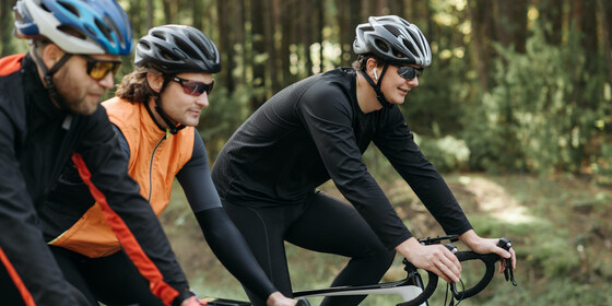
Nomads Friday Cycling - virtually every Friday
10:30 – 16:00
Do you enjoy cycling, and are you sometimes free on Fridays? You're welcome to join the Nomads Friday cyclists.
** See Archive - Friday Bike Rides for the upcoming Friday's cycling details (posted on Wednesday night). **
GRADE | LENGTH | TYPE: Rides are of varying length and difficulty, mostly in metro Melbourne, but sometimes in Regional Victoria. The typical distance is between 30 and 50 km, though there are usually options to either extend or shorten the ride.
ACTIVITY DESCRIPTION: Time off on Fridays? Join a small group of Nomads and friends for a leisurely cycle on trails around metro Melbourne, and occasionally into Regional Victoria. Emphasis is on the social aspect, not on breaking world speed records! All rides are designed to either start in central Melbourne, or to start and finish close to train stations. The rides usually start at around 10:30am to avoid needing to travel with bikes on trains in peak hour. We often meet in, or near, a cafe so you can have a coffee prior to starting the ride if you wish. We generally have lunch in a cafe or pub along the way, though occasionally you will need to bring a picnic lunch if there are no suitable options available - in that case the ride description will clearly indicate the need to BYO lunch.
The upcoming ride details are usually posted on the prior Wednesday evening at the start of the Archive - Friday Bike Rides document, by which time the weather forecast for Friday is fairly reliable. That way, a ride can be chosen to suit the forecast, for example to keep the wind behind us as much as possible, and to ensure there are bailout train station options if there’s a likelihood of rain.
If you have any additional enquiries or requests, email Alan Drummond on LeaderAland@nomads.org.au or phone 0415 771 220. If you're not sure if your bike fitness level will match, contact Alan to plan your first foray.
BOOKING:
Mailing List: To join the mailing list so that you receive an email (usually on Wednesday evening) about the upcoming Friday ride, click on Get Tickets in this event. Afterwards click the "+" to set the number of tickets to 1, click Checkout and follow the prompts to provide your contact details. You only need to do this once. If you decide in future that you don't wish to receive the weekly emails, please email LeaderAland@nomads.org.au to be taken off the mailing list.
Riding: When you plan to ride, please put your name in a free cell of the Friday Attendees spreadsheet on the day prior (be sure to click out of the cell afterwards, so that your name gets automatically saved). If a blank cell has a coloured box around it, somebody else is currently entering their name in that cell, so select the next cell instead. Your first name plus the first letter of your surname will suffice. If having difficulty, just reply to the weekly email or email LeaderAland@nomads.org.au.
COST: Free. Note that for most Nomads activities, visitors need to pay a small fee, but as an introductory offer that fee is waived for the monthly social nights and the Friday bike rides - a way for you to meet some club members and find out a little more about the club. After attending 5 or more rides, you will be asked to become a member though.
FURTHER INFORMATION: Please see Cycling Tips for some things to consider prior to hopping on your bike.
LEADER: Alan D. | Email LeaderAland@nomads.org.au if you have any questions.
Members can access leader contact details under Members | Leader Contacts when logged in to the website.
HOME BACK TO LIST OF EVENTS MEMBERSHIPS
Past events
Jul
12
Past Event
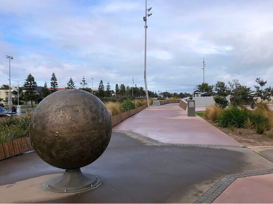
The Melbourne Solar System walk
Beacon Cove/Light Rail
10:30 – 15:30
An easy mid-winter walk from Pluto to the Sun visiting Neptune, Uranus, Saturn, Jupiter, Mars, Earth, Venus and Mercury en-route.
GRADE | LENGTH | TYPE: Grade 1: Easy 8 Billion km point to point walk (8 km) (graded according to the AWTGS: Australian Walking Tracks Grading System).
ACTIVITY DESCRIPTION: An easy winter's walk following the Bay Trail - the Melbourne Solar System walk section, from Port Melbourne to St Kilda. The trail from Pluto to the Sun is 5.9 Billion km long (5.9 km). At Port Melbourne we will also walk out on Princes Pier and to the Port Melbourne Lookout. At St Kilda we can walk the new St Kilda Pier and Breakwater and have refreshments at the St Kilda Pier Kiosk or wait until we get to Acland Street.
BOOKING: By Friday 10th July. To register click on Get Tickets.
Unsure if you've already booked? Click View my bookings.
FURTHER INFORMATION: Transport Victoria | Solar System Trail
MEETING TIME | LOCATION: 10:30am at the Port Melbourne Tram Terminus - Beacon Cove/Light Rail. Tram arrives at 10:25am, departs Southern Cross at 10:11am.
MAP REFERENCE: Google map maps.app.goo.gl/vawpcXvbzJYTKFar9
DISTANCE | TIME FROM GPO: 4.5 km, approximately 14 minutes by tram from Southern Cross Station.
PUBLIC TRANSPORT: For the 2nd half of 2026, fares are at 1/2 price - myki money weekend daily cap is $4.00 + Seniors FREE. Travel time from Southern Cross is 14 minutes. Departs Southern Cross (Collins St) at 10:11am, Arrives Port Melbourne 10:25am. If you would like something to eat or drink before the walk, plan to arrive 40 to 60 minutes earlier. Mr Hobson, 9 Waterfront Place looks like the only option nearby as the other cafes are closed at the time we are there. Return tram: From Acland Steet, St Kilda - #96 tram, 28 minutes to Southern Cross Station.
FOOD: Mr Hobson, 9 Waterfront Place for pre-walk food and drinks. We will have a lunch stop near Uranus. The Sandbar should be open for meals / take away if you do not bring lunch. Carry lunch, snacks and a litre of water. We can stop at the St Kilda Pier Kiosk or go to Acland Street for after-walk refreshments.
APPAREL | FOOTWEAR: Comfortable walking boots/shoes and dress according to the weather forecast. It's the middle of winter, so be prepared - it's cold in space, also possible meteor showers and strong solar winds (possible cold, wet and windy conditions).
LEADER: Paul K. | Email LeaderPaulK@nomads.org.au if you have any questions.
Members can access leader contact details under Members | Leader Contacts when logged in to the website.
Image: Visit Victoria
HOME BACK TO LIST OF EVENTS MEMBERSHIPS
Jul
07
Past Event
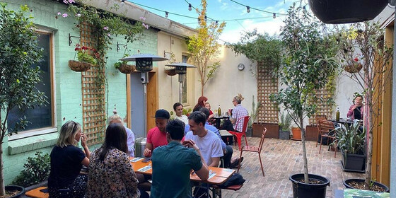
July Social Night - Vic Hotel, Footscray
Victoria Hotel Footscray
19:00 – 21:00
Our regular monthly social night - this month at the Vic Hotel - Footscray.
GRADE: Social.
ACTIVITY DESCRIPTION: The Nomads hold a social night each month, where members and guests can enjoy a meal, talk about upcoming events, compare notes on past activities and float ideas on events they would like to see run. Do you want to see more of a particular activity, or do you have a particularly favourite area of Victoria you would like to share with others? Do you have an idea for a walk we haven't done before? If so, we'd love to hear from you. Everyone is welcome – new members are especially invited to any of the monthly Nomads social evenings.
Tuesday nights are $25 pie nights - served with mash and peas, or check out the Victoria Hotel Menu.
BOOKING: By Sunday 5th July. To register, click on Get Tickets.
Unsure whether you've booked already? Click View my bookings.
MEETING TIME | LOCATION: 7pm on Tuesday 7th July at the Victoria Hotel, 43 Victoria St, Footscray.
MAP REFERENCE: Google map goo.gl/maps/MCvdPVENFaUDWKEv7.
PUBLIC TRANSPORT: The Vic Hotel - Footscray is very close to Middle Footscray Station on the Watergardens/Sunbury line. However, due to planned works on Tuesday night, the last train towards the CBD will depart at 8:28pm. After that you'll need to catch a bus replacement service, walk to Footscray Station, or catch a standard suburban bus service (e.g. bus 216 or 220 from 72 Paisley St).
LEADER: Alan D. | Email LeaderAlanD@nomads.org.au if you have any questions.
Members can access leader contact details under Members | Leader Contacts when logged in to the website.
HOME BACK TO LIST OF EVENTS MEMBERSHIPS

Jul
06
Past Event
Spring Program Pre-planning - Online via Zoom
19:00 – 20:00
Preparing the draft Spring program of events - online via Zoom.
GRADE: Social.
ACTIVITY DESCRIPTION: The bulk of the planning for the upcoming Spring program will be done in this pre-planning meeting via Zoom in readiness to present the draft program the next night at the Social Evening, where attendees will be invited to provide additional suggestions and help fill any gaps.
BOOKING: By 5pm Monday 6th July. To register, click on Get Tickets. Alternatively, simply click on the Zoom link in the reminder email sent to members a few days prior to the event.
Unsure if you've already booked? Click View my bookings.
DRAFT PROGRAM: Nomads Draft Program. You may add your suggestions to this online spreadsheet - be sure to click to some other cell once you've finished, so that your suggestion gets saved.
MEETING TIME | LOCATION: 7pm online via Zoom. Those who registered will be sent the Zoom link by 6pm on Monday evening.
LEADER: Alan D. | Email LeaderAlanD@nomads.org.au if you have any questions.
Members can access leader contact details under Members | Leader Contacts when logged in to the website.
Photo by Bich Tran from Pexels.
HOME BACK TO LIST OF EVENTS MEMBERSHIPS
Jun
28
Past Event
Bundoora Park Loop Walk
11:00 – 15:00
Suburban park in northern Melbourne, near La Trobe University.
GRADE | LENGTH | TYPE: Grade 2: Easy-Moderate 6-10 km circuit walk (graded according to the AWTGS: Australian Walking Tracks Grading System).
ACTIVITY DESCRIPTION: Vast grassy plains and panoramic views from the highest point in metropolitan Melbourne define this accessible circuit through Bundoora Park. Centred around Mount Cooper, this loop offers a straightforward escape into the northern suburbs' largest parkland. The main Boondurra loop is 5.5 km, with optional 4 km loop through the Gresswell Forest.
The trail provides a varied mix of surfaces, including paved shared paths, the shoulders of quiet internal roads, and open stretches across the grass. While much of the route skirts the local golf course and residential edges, the climb up Mount Cooper is a highlight, offering clear vistas across the city skyline and the surrounding ranges. Because the trail is quite open, there is very little shade along the way.
BOOKING: By Friday 26th June. To register, click on Get Tickets.
Unsure if you've already booked? Click View my bookings.
MEETING TIME | LOCATION: 11am at Bundoora Park entrance near tram stop. There is parking inside the park to the left.
PUBLIC TRANSPORT: Number 86 tram to Bundoora Park / Plenty Road tram stop.
MAP REFERENCE: Google map: https://maps.app.goo.gl/Jurs4swBQc2MNeuf7
FOOD: Carry lunch, snacks and a litre of water.
APPAREL | FOOTWEAR: Comfortable walking boots and dress according to the weather forecast.
LEADER: Richard C. | Email LeaderRichardC@nomads.org.au if you have any questions.
Members can access leader contact details under Members | Leader Contacts when logged in to the website.
HOME BACK TO LIST OF EVENTS MEMBERSHIPS

Jun
21
Past Event
The Nomads Winter Solstice Dinner
Shamiat Authentic Syrian Restaurant
18:30 – 21:30
Join us for the annual Nomads Winter Solstice Dinner.
ACTIVITY DESCRIPTION: Treat your taste buds to the exciting flavours of Syrian cuisine at Shamiat, a family-run restaurant bringing the taste of Syria to Melbourne. From kibbeh to falafel and hummus, they offer a variety of vegan, vegetarian, and gluten-free options for everyone to enjoy! Their chef, Helda, has been perfecting Syrian dishes for more than 20 years! Come along for an authentic, home-made-style spread.
We will be indulging in a 3 course banquet. For any special dietary requirements please contact the event leader.
This is a BYO wine (or beer) restaurant, with a $5 corkage fee per bottle of wine. You can pick up a wine or beer on the way at the Wine Republic, 226 High St, Northcote or BWS Northcote, 2 Charles St, Northcote. Non alcoholic drinks can be purchased at the restaurant.
BOOKING: By Friday 19th June. To register click on Get Tickets.
Unsure if you've already booked? Click View my bookings.
FURTHER INFORMATION: shamiat.com.au
MEETING TIME | LOCATION: 6:30pm with a plan to start eating around 7 pm. Shamiat Restaurant, 60 Victoria Rd, Northcote.
MAP REFERENCE: Google map: maps.app.goo.gl/1URxBZxyAKU6rFh46.
PUBLIC TRANSPORT: Catch the Hurstbridge line train that departs from Flinders Street Station at 5:59pm and arrives at Dennis Station at 6:23pm. The restaurant is a 5 minute walk from there.
LEADER: Greg W. | Email LeaderGregW@nomads.org.au if you have any questions.
Members can access leader contact details under Members | Leader Contacts when logged in to the website.
HOME BACK TO LIST OF EVENTS MEMBERSHIPS
Jun
21
Past Event
Sunday Morning Training Ride - 21 June
08:00 – 12:00
Sunday morning fitness ride from Fed Square to Hampton/Black Rock and return.
GRADE | LENGTH | TYPE: Approximately 29 km one way and various distances on the return. Mainly flat. The route includes city paths, bike trails and some road riding. Riders returning to Flinders Street will ride approximately 50+ kilometres, depending on their route back to the city.
ACTIVITY DESCRIPTION: This is a Sunday morning ride from the city to Hampton or Black Rock return. The ride will focus on steady riding to improve fitness. It will include one coffee stop on the return section and will aim to be fully concluded by late morning. The ride will include bicycle paths and some roads. In sections, riders will have the choice to ride on the road or on designated bicycle paths (Port Melbourne - Black Rock).
We will take the path beside the Yarra River to Docklands, link to Lorimer Street then proceed through Westgate Park to Port Melbourne. We will take bike paths along the Port Melbourne foreshore to Beaconsfield Pde. At this point riders can choose to follow the Bay Trail or road-ride to Black Rock.
At Black Rock Clock Tower, after a short 5-10 min drink break we will begin our return journey, stopping for coffee somewhere along the way - choices include Hampton, Brighton, St Kilda, or Albert Park. From the coffee stop, riders will choose the most convenient route home via the city, southern suburbs, west, east or north.
Note: If the trip to the Clock Tower is too lengthy we could turn around at Hampton. We will see how long the ride takes to complete.
If the weather forecast is very poor, such as heavy rain or wind gusts, a cancellation email will be sent on Saturday evening by 8:30 pm or Sunday morning by 6:30 am.
BOOKING: By Friday 19th June. To register click on Get Tickets.
Unsure if you've already booked? Click View my bookings.
MEETING TIME | LOCATION: Ride will depart at 8:00am sharp and will not wait for latecomers. Meet at the junction of Swanston St and Birrarung Marr Walk (opposite Flinders Street Station) between 7:50am and 8:00am.
MAP REFERENCES:
Meeting Point - Google map: Birarung Marr Walk
Ride Route - Google
PUBLIC TRANSPORT: Take a train or ride to the start point. Ride or take public transport home from the CBD. Riders needing to opt out on the return could access stations along the Sandringham line.
APPAREL | FOOTWEAR: Riding attire and wet weather gear. Carry water, money, phone, puncture kit, rain jacket.
LEADER: Bryan S | Email LeaderBryanS@nomads.org.au if you have any questions.
Members can access leader contact details under Members | Leader Contacts when logged in to the website.
HOME BACK TO LIST OF EVENTS MEMBERSHIPS