

The Nomads Outdoors Group Inc.
Powered by
Past events
All events
Past events

Feb
05
2023
Past Event
The Nomads at Midsumma Pride March
Ian Johnson Oval
09:00 – 16:00
Gather your friends together, and your Nomads polo shirt, and head along to Fitzroy St, St Kilda to march with The Nomads in the annual Midsumma Pride March.
GRADE | TYPE: Easy, social.
ACTIVITY DESCRIPTION: Midsumma Pride March in 2023 will be totally free of COVID-19 restrictions, so come along to march with us, or cheer us on from the sidelines.
The best view of the parade is always from within it though, so register via Get Tickets to join The Nomads in marching proudly down Fitzroy Street. See midsumma.org.au closer to the date for comprehensive details.
BOOKING: By Friday 3rd February. To register, click on Get Tickets.
Unsure if you've already booked? Click View my bookings.
MEETING TIME | LOCATION: probably 9:30am - we will be notified of our assembly time closer to the event | Ian Johnson Oval, Fitzroy St, St Kilda.
MAP REFERENCE: Melway map 2P grid B3 | Google map goo.gl/maps/rNZFmL1Pz16aCqD18.
PUBLIC TRANSPORT: 12 to stop 143 | tram 96 to stop 132 | any St Kilda Rd tram to stop 30 (these tram stops will be serviced even while the march is proceeding).
LEADER: Garry O. | Email LeaderGarryO.thenomadsinc@mail.tidyhq.com if you have any questions.
Members can access leader contact details under Members | Leader Contacts when logged in to the website.
Image: Zack M.
HOME BACK TO LIST OF EVENTS MEMBERSHIPS
Jan
28
2023
Past Event
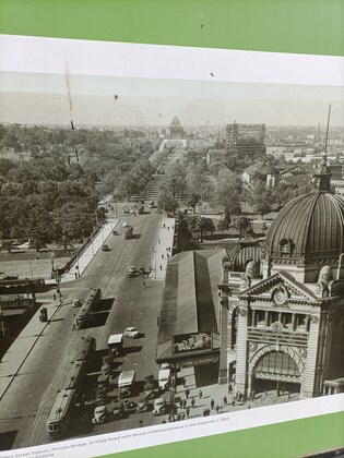
Midsumma Walk: Evolution Of St Kilda Road Through A Gay Nomads Lens
Federation Square
10:30 – 16:00
** This event has booked out. If you would like to attend, please get a WAITLIST ticket and we'll contact you if places become available. **
Get the lowdown on Melbourne's grandest boulevard in this walk that has been specially designed to be part of Midsumma Festival. ** Click on GET TICKETS to book your free ticket.
GRADE | LENGTH | TYPE: Easy short point-to-point walk, on made paths with minimal inclines.
ACTIVITY DESCRIPTION: Starting as a swamp, Melbourne's grandest boulevard has developed into a key commercial and entertainment area, plus having varied installations recognising exceptional events and people. The walk explores major St Kilda Road features, with background stories, from Federation Square to Toorak Road. Gay people and gay life are a part of this evolution and history. The walk concludes at Gate "D" Botanical Gardens. Dress for warm weather, with sunscreen, sunhat and closed footwear. BYO water (refills available), snacks and lunch.
** This event is part of Midsumma Festival 2023.
BOOKING: By Thursday 26th January. To register, click on Get Tickets.
Unsure if you've already booked? Click View my bookings.
MEETING TIME | LOCATION: 10:30am near the corner of Princes Walk and Swanston St. That's at Federation Square, opposite Flinders Street Station, on the river side of Transport Hotel.
MAP REFERENCE: Melway map 1B grid N 11 | Google map: goo.gl/maps/adqwNYCcrEyU9S3y6
FOOD: Carry lunch, snacks and a water bottle (refills available along the route).
APPAREL | FOOTWEAR: Face mask, hand sanitiser and dress for warm weather with sunscreen, hat and closed footwear.
LEADER: Garry O. | Email LeaderGarryO.thenomadsinc@mail.tidyhq.com if you have any questions.
Members can access leader contact details under Members | Leader Contacts when logged in to the website.
HOME BACK TO LIST OF EVENTS MEMBERSHIPS
Jan
26
2023
Past Event
Australia / Rum Rebellion Day at Blanchfields 26 January **CANCELLED
12:00 – 16:00
** Unfortunately, this event has had to be cancelled. Robert has had a fall and is still in hospital with cracked ribs and a punctured lung. He's on the mend though! **
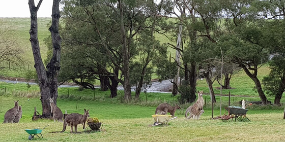
Enjoy a casual picnic on 26 January on the property of a Macclesfield member, which includes a swimming pool, expansive outdoor picnic area, historic features and some delightful walking trails.
GRADE | LENGTH | TYPE: Social - picnic with optional camp out overnight at "Blanchfields", a private home overlooking the Yarra Valley.
ACTIVITY DESCRIPTION: We are very privileged to be invited to a picnic in the private and beautiful gardens of the home of member Robert A. It is a rural property with a large garden of exotic trees and shrubs, grasslands and some bushlands overlooking the Yarra Valley. Robert has also invited guests to stay the night after the day of revelry if you wish. You are welcome to set up your tents or trailers in the gardens and leave the next day. In that case, Robert will direct you where you can set up camp.
The event starts from midday onwards. There are a limited number of chairs and tables as well as a toilet and bathroom for use. Note – this is not a barbeque. Fires are not allowed in a high fire danger area. Enjoy the swimming pool and stay over in your tent or camper if you wish. There will be access to the oven/stove if anything needs cooking or heating up. Plus, the vegetable garden should be in full production if we need additional ingredients. Updates will follow closer to the date. There will be a short walk around the property later in the afternoon.
BOOKING: by Monday 23rd January. To register, click on Get Tickets.
Unsure if you've already booked? Click View my bookings.
MEETING TIME | LOCATION: From midday onwards at the private home of member Robert A. located in Macclesfield (past Emerald). Address will be forwarded once you have booked a ticket.
MAP REFERENCE: Melway map X912 grid R4 | Google map goo.gl/maps/KBZiiJpW2uj.
DISTANCE | TIME FROM GPO: 1 hour – about 60 km.
TRANSPORT: No public transport. Travel by car and carpool with someone else if you can. Take the Monash or Eastlink Freeway and exit at Wellington Rd then continue to Macclesfield. The full address and travelling directions will be provided to you upon receipt of your RSVP.
FOOD: Bring your own food and drink. For those staying the night, there will be shared drinks, nibbles and meal on the deck at sunset. Until we know how many will be taking part, let’s just call it a “potluck dinner”, any contributions gratefully received.
APPAREL | FOOTWEAR: Bring your own hat, sunscreen and insect repellent. Dress according to the weather forecast.
LEADER: Robert A. | Email LeaderRobertA.thenomadsinc@mail.tidyhq.com if you have any questions.
Members can access leader contact details under Members | Leader Contacts when logged in to the website.
HOME BACK TO LIST OF EVENTS MEMBERSHIPS
Jan
21
2023
Past Event
Naturist Mixed Bushwalk to old gold mine, poisoned lake & The Monk, Castlemaine
58 Lyttleton St
10:30 – 16:00
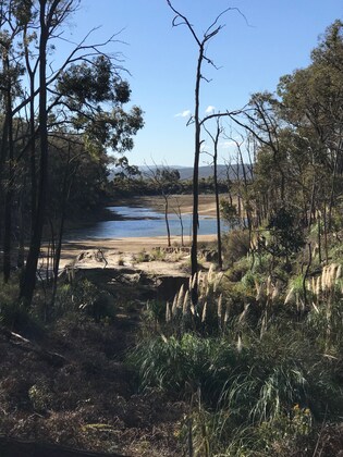
Enjoy a naturist bushwalk in the forest at the back of historic Chewton, past the old Union Hill Gold Mine and the poisoned lake, to eventually reach The Monk (a significant hill) with great views over Castlemaine.
GRADE | LENGTH | TYPE: Moderate 9 km circuit walk. The walk is generally undulating and of medium difficulty. The ascent to the top of The Monk though is reasonably steep, but fortunately quite short. If you don't have the energy to reach the top, you can walk around the bottom and meet us on the other side.
ACTIVITY DESCRIPTION: Enjoy a naturist social day out. We start off with coffee and snacks at a cafe in Castlemaine before travelling 5 km to the start of the walk. There we can get suitably unattired and enjoy our outing in the remote forest. We'll have lunch out in the forest before making our way back to the start.
After the walk we have been invited back to an optional naturist afternoon tea at a local house with optional massage exchange and a hot shower to follow. Should it be very hot, some of us may wish to go to the local reservoir for a cool off swim.
BOOKING: By Thursday 19th January. To register click on Get Tickets.
Unsure if you've already booked? Click View my bookings.
MEETING TIME | LOCATION: 10.30am at Togs Place Cafe, 58 Lyttleton St, Castlemaine.
MAP REFERENCE: Melway map X909 grid D6 | Google map goo.gl/maps/qiRf1J2RHJhMYMbd8.
DISTANCE | TIME FROM GPO: 120 km, approximately 1 hour 25 minutes via Calder Fwy/M79, and then turning left (west) on the Pyrenees Highway/B180 to reach Castlemaine.
PUBLIC TRANSPORT: At the time of writing there seems to be no suitable public transport available. It may change closer to the event date. It's probably best to email the leader who may be able arrange a lift from Melbourne for you.
FOOD:
For the walk: Carry lunch, snacks and a litre of water.
For the optional afternoon tea, tea and coffee are provided, but if you'd prefer a cold drink could you please BYO. Cold drinks may be left in a fridge while we are out walking.
APPAREL | FOOTWEAR: Comfortable walking boots/shoes, sunhat, sunscreen and dark glasses. Shorts or similar may be needed at the start of the walk. Swimming togs in case we go for a swim in the local lake swimming area. A towel to sit on at the optional naturist afternoon tea.
COST:
For the Walk, Nomads members free, visitors $5 when you buy your ticket online on this website.
For the optional afteroon tea and masssage exchange including a hot shower, $5 cash to the home owner on the day.
LEADER: Russell W. | Email LeaderRussellW.thenomadsinc@mail.tidyhq.com if you have any questions.
Members can access leader contact details under Members | Leader Contacts when logged in to the website.
HOME BACK TO LIST OF EVENTS MEMBERSHIPS
Jan
15
2023
Past Event
Currawong Falls, Aireys Inlet day walk
40 Great Ocean Rd
10:00 – 16:00
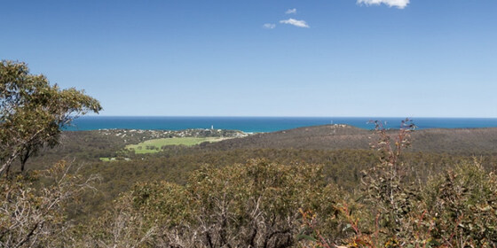
Spend a day in the glorious ironbark forests behind Aireys Inlet, with views over the sea.
GRADE | LENGTH | TYPE: Medium 12.5 km circuit walk on formed track. It undulates, but there is no sustained climbing. With current rain the track can be slippery. The walk climbs up to 230m and then down again.
ACTIVITY DESCRIPTION: This very scenic walk passes through rainforest, and dry forests behind Aireys Inlet. We will all meet at the General Store in Aireys inlet (on the left on the main road). From there we will drive in convoy to the start. There are no facilities during the walk, and we will have a picnic lunch along the way.
After the walk we will stop for afternoon tea at an establishment in Aireys Inlet for those who want.
BOOKING: By Friday 13th January. To register, click on Get Tickets.
Unsure if you've already booked? Click View my Bookings.
FURTHER INFORMATION: Map of the route: Distillery Creek Picnic Area - Currawong Falls Circuit.
MEETING TIME | LOCATION: 10:00am at the Aireys Inlet General Store, 40 Great Ocean Rd, Aireys Inlet. Type "Aireys Inlet General Store" into Google Maps.
MAP REFERENCE: Melway map X911 grid C10 | Google map goo.gl/maps/Ue4ekLE1NbvK5ZqL7.
DISTANCE | TIME FROM GPO: 130 km from Melb GPO. Allow 1 hour 40 minutes to drive to the meeting point (head towards Geelong, then past Anglesea along the Great Ocean Road).
PUBLIC TRANSPORT: Not available on Sunday morning.
FOOD: Bring lunch, and also at least 1 litre of water depending on how hot the day is.
APPAREL | FOOTWEAR: Light comfortable walking footwear (good grip for slippery track), and dress according to the weather forecast. Check the weather forecast before leaving. It can be very hot and sunny, or quite cool and wet near the ocean.
LEADER: Roger H. | Email LeaderRogerH.thenomadsinc@mail.tidyhq.com if you have any questions.
Members can access leader contact details under Members | Leader Contacts when logged in to the website.
HOME BACK TO LIST OF EVENTS MEMBERSHIPS
Jan
10
2023
Past Event
Autumn Program Planning & Social Night - Victoria Hotel, Footscray
Victoria Hotel Footscray
19:00 – 21:00
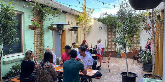
Our quarterly planning night, in conjunction with the regular monthly social night - this month at the Victoria Hotel. PLEASE take a few moments to book a FREE ticket to (1) ensure there are adequate seats available and (2) you can be included in confirmation emails.
GRADE: Social.
ACTIVITY DESCRIPTION: The Nomads hold a social night each month, where members and guests can enjoy a meal, talk about upcoming events, compare notes on past activities and float ideas on events they would like to see run. At the quarterly planning meetings, in addition to the monthly social activities the draft program, which will have been prepared via a Zoom pre-planning meeting the previous night, is presented so attendees can make suggestions or fill in any gaps. Do you want to see more of a particular activity, or do you have a particularly favourite area of Victoria you would like to share with others? Do you have an idea for something apart from the regular walks? We'd love to hear from you. Everyone is welcome – you don't have to volunteer for an activity. New members are especially invited to this, or any of the monthly Nomads social evenings.
Check out the Victoria Hotel Menu - Tuesday nights are parma nights.
BOOKING: By Sunday 8th January. To register, click on Get Tickets.
Unsure what you've booked for? Click View my bookings.
MEETING TIME | LOCATION: 7pm at the Victoria Hotel, 43 Victoria St, Footscray.
MAP REFERENCE: Melway map 2S grid C9. Google map goo.gl/maps/MCvdPVENFaUDWKEv7.
PUBLIC TRANSPORT: The Victoria Hotel is close to Middle Footscray Station on the Watergardens/Sunbury line.
LEADER: Garry O. | Email LeaderGarryO.thenomadsinc@mail.tidyhq.com if you have any questions.
Members can access leader contact details under Members | Leader Contacts when logged in to the website.
HOME BACK TO LIST OF EVENTS MEMBERSHIPS

Jan
09
2023
Past Event
Autumn Program Pre-planning - Online via Zoom
19:00 – 20:00
Preparing the draft Autumn program of events - online via Zoom.
GRADE: Social.
ACTIVITY DESCRIPTION:
The bulk of the planning for the Autumn program will be done in this pre-planning meeting via Zoom in readiness to present the draft program the next night at the Social Evening, where attendees will be invited to provide additional suggestions and help fill any gaps.
BOOKING: By 5pm Monday 9th January. To register, click on Get Tickets. Alternatively, simply click on the Zoom link in the reminder email sent to members a few days prior to the event.
Unsure if you've already booked? Click View my bookings.
DRAFT PROGRAM: Nomads Draft Program.
MEETING TIME | LOCATION: 7pm online via Zoom. Those who registered will be sent the Zoom link by 6pm on Monday evening.
LEADER: Garry O. | Email LeaderGarryO.thenomadsinc@mail.tidyhq.com if you have any questions.
Members can access leader contact details under Members | Leader Contacts when logged in to the website.
Photo by Bich Tran from Pexels.
HOME BACK TO LIST OF EVENTS MEMBERSHIPS
Jan
08
2023
Past Event
Warrandyte State Park - Jumping Creek Reserve
11:00 – 16:00
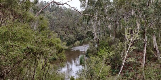
This is a circuit of one area of Warrandyte State Park. The trail is rocky, varies in width from wide in some sections to narrow in others, and features views across the surrounding green rolling Warrandyte hills and of the serene Yarra River. ** This event was postponed from 20 November due to flooding of the trail **
GRADE | LENGTH | TYPE: Easy 8 km circuit walk.
ACTIVITY DESCRIPTION: This route passes through hills with large grey kangaroo populations, who often might take a minute to shuffle off the track before you proceed to pass. This section also passes an abandoned farm house, before reaching a sitting bench to stop and rest overlooking the bend of the Yarra River.
BOOKING: By Friday 6th January. To register, click on Get Tickets.
Unsure if you've already booked? Click View my bookings.
MEETING TIME | LOCATION: 11:00am at the Jumping Creek Sandy Bay Carpark.
PUBLIC TRANSPORT: Public transport is not viable
MAP REFERENCE: Melway map 24 grid A10 | Google map: goo.gl/maps/tAWe7GwgHhpcdhhj9.
FOOD: Carry lunch, snacks and a litre of water.
APPAREL | FOOTWEAR: Face mask, hand sanitiser, comfortable walking boots and dress according to the weather forecast.
LEADER: Richard C. | Email LeaderRichardC.thenomadsinc@mail.tidyhq.com if you have any questions.
Members can access leader contact details under Members | Leader Contacts when logged in to the website.
HOME BACK TO LIST OF EVENTS MEMBERSHIPS
Jan
07
2023
Past Event
Mens Only Naturist Beach Day at Somers & Men's only Naturist drinks at Bittern
Somers Beach
10:30 – 16:00
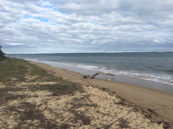
Enjoy a relaxed day out at the Somers naturist beach.
GRADE | LENGTH | TYPE: Easy 7 km circuit walk. It is a pleasant 3.5 km walk along the beach from the car park in Somers towards Sandy Point to a good setup place in the sand dunes. The sand is fairly firm. Walking time is generally about 55 minutes to the setup place. Most of the beach walk can be done minus clothes once we get past the local dog walkers close to Somers. Of course it is another approx 3.5 km back to the cars at the end of the day.
ACTIVITY DESCRIPTION: This event is for naturists. Enjoy a pleasant relaxing beach day - walk, swim and sunbake with other fellow naturists.
After the beach we have been invited to a men's naturist drinks at a fellow nudist's residence in Bittern, 10 minutes drive away. (Apologies, the afternoon tea is a men's-only gathering).
BOOKING: By Thursday 5th January. To register, click on Get Tickets.
Unsure if you've already booked? Click View my bookings.
MEETING TIME | LOCATION: 10.30am in the car park at 121 Miramar Rd, Somers.
There is no cafe near the meeting place sorry, you will need to bring your coffee with you. (You can get coffee in Bittern at Remuce Cafe or the Bittern Bakery and Cafe).
We plan to depart from the car park for the beach at about 11am. If you should miss us, or wish to come at a different time, walk to the side of the car park nearest the beach and go down the steep steps to the beach. At the bottom of the stairs turn left and walk for about 55 minutes and you should find our camp.
Food Drop off in the Morning: If you'd like to drop off food before you come to the beach, you may drop it at the house in Bittern between 9.45am and 10.15am. The house is 1 hour 20 minutes, and 82 km from Melbourne - a long way! Make sure you plan your time. From the house to the meeting place it is a 10 minute drive.
Address of the Afternoon Tea House: This will be emailed to all those who have booked by 10pm on Wednesday 4th January. It will also be given out on the beach day.
TIDE FORECAST: Low 7:40am - High 1:27pm - Low 7:33pm. The tide may be getting up when we leave from the carpark for the beach starting to getting lower when we leave the beach to come back in the afternoon. (For those who haven't been to Somers, it can be quite difficult to climb over the fallen trees on the beach at high tide.)
MAP REFERENCE: Melway map 194 grid F11 | Google map goo.gl/maps/6AUdGMw3E9BwtP38A.
DISTANCE | TIME FROM GPO: 86 km, about 1 hour 20 minutes to 1 hour 30 mins depending on which route you take.
FOOD:
FOOD and BEVERAGES for the BEACH DAY: Carry lunch, water and any other food/drinks you may like for the beach day.
FOOD and DRINKS for the AFTERNOON: Please bring some food to share for afternoon at the Bittern residence after the beach day. Tea and coffee will be provided. Bring cold drinks if you would prefer those.
APPAREL: Sunscreen, hat, sun glasses, footwear if the sand is hot. Shorts required to get from car park to the naturist beach.
EQUIPMENT: Towel. A picnic blanket with plastic backing or a large plastic sheet is handy, because in some places the grass seeds stick tightly to your towel and are very hard to get out. You may wish to bring a sun shelter. The tea tree provides quite good, but not complete, shade cover. Sporting equipment such as a frisbee, tennis ball, larger ball, small cricket bat etc. could be fun.
LEADER: Peter H. | Email LeaderPeterH.thenomadsinc@mail.tidyhq.com if you have any questions.
Members can access leader contact details under Members | Leader Contacts when logged in to the website.
HOME BACK TO LIST OF EVENTS MEMBERSHIPS
Jan
07
2023
Past Event
Mt Dandenong Hike - Kalorama to Sassafras via Doongalla Forest
Croydon Railway Station/Railway Grove
09:45 – 17:00
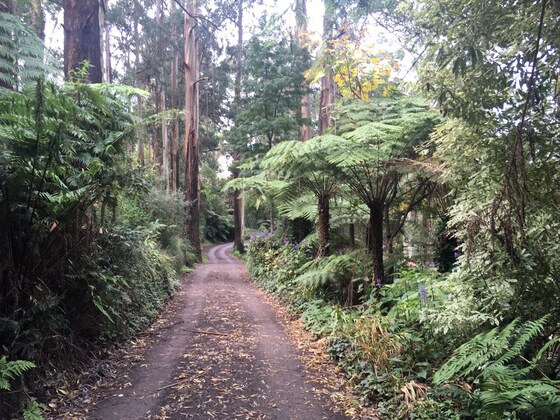
Escape the city and enjoy a full-day spring hike through the picturesque Dandenong Ranges, on what will be a unique event, taking in the lush scenic forest, birds, views of the city, walking tracks, falls and the crisp/fresh air. This event caters for the experienced/ fit hiker who demands a 'real hike' and wants to break out a sweat. This event is graded 'hard to challenging' with a number of steep short inclines throughout.
GRADE | LENGTH | TYPE: Hard -> Challenging (in sections), approximately 12.5 km, this event caters for experienced hikers and those with fitness levels that are able to climb short steep tracks. This event is not suitable for first timers or those with limited fitness abilities. If in doubt, contact the leader prior to booking to discuss your fitness levels/suitability for the hike.
ACTIVITY DESCRIPTION:
We will meet at Croydon Station before boarding a bus for our first section of the hike at Kalorama.
Part 1: Kalorama GPO to Five Ways lookout (incline) with a stop at the coffee shop. From here we take a steep incline along the Trig/Kyeema Track and will explore the Kyeema crash site, followed by views near Burke's lookout. Then after a steep descent, we will arrive at Doongalla Picnic Reserve for lunch.
Part 2: From the reserve we will walk through the dense scrub incline along the Dandenong Creek Track and make our way through a steep incline to arrive at Sassafras township. After exploring the township, we will make our way back by bus to Croydon Station.
BOOKING: By Friday 6th January. To register, click on Get Tickets.
Unsure if you've already booked? Click View my bookings.
FURTHER INFORMATION: explorethedandenongs.com.au/western-slopes-trail-mt-dandenong
MEETING TIME | LOCATION: 09:45am at Croydon Train Station, Railway Grove. Exact meetup points will be provided via email prior to the event. This is intended to be a public transport friendly event where the start and end points will be accessible by train. There is no carpooling for this event, however, you may organise your own lift with fellow walkers if you wish.
MAP REFERENCE: Melway map 50 grid J3 | Google map goo.gl/maps/LhvezYQ8CpHcSDoy7.
DISTANCE | TIME FROM GPO: 35 km, approximately 35 minutes to drive, 50 minutes by public transport. There is car parking available at the train station for those who wish to drive. We will all take the bus to the start of the walk regardless of whether you drive to the meeting spot or not. You will need a Myki card for this event and a face mask is recommended for the ride on public transport.
PUBLIC TRANSPORT: This is a public transport friendly event.
By Train: Take the Lilydale train from Flinders Street and get off at Croydon Station. As a group we will then catch the #688 bus to the starting point of the walk. At the conclusion of the walk, the same bus will take us back to Croydon, with a connecting train back to the CBD.
FOOD/DRINKS: Carry lunch, snacks and at least 1-2 litres of water. Also bring sunscreen and a hat. A facemask is recommended for public transport. Bring your Myki card for the return trip by train/bus. We will stop briefly at a coffee shop where you can buy a coffee, and there may be options to purchase food for lunch (although this may be costly). There will also be a late afternoon tea stop in Sassafras at the conclusion of the official hike.
APPAREL | FOOTWEAR: Suitable boots/hiking shoes and dress according to the weather forecast (layering). The mountains are usually a few degrees cooler but you will quickly warm up as you begin the hike! Ensure your shoes are waterproof as some of the paths most likely will be a little wet/muddy and a bit slippery if it has rained heavily prior to the event. Your boots will get some dirt/mud on them!
LEADER: Jason T. | Email LeaderJasonT.thenomadsinc@mail.tidyhq.com if you have any questions.
Members can access leader contact details under Members | Leader Contacts when logged in to the website.
HOME BACK TO LIST OF EVENTS MEMBERSHIPS
Jan
02
2023
Past Event
Picnic at Newport Lake
Newport Lakes Reserve
11:00 – 16:00
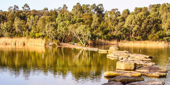
Enjoy a leisurely picnic and walk around one of Inner Melbourne's hidden treasures - the Newport Lakes. Monday is a declared Public Holiday (offset for New Years Day being on a Sunday).
GRADE | LENGTH | TYPE: Picnic and short walk around the Newport Lakes park.
ACTIVITY DESCRIPTION: Newport Lakes, managed by the City of Hobsons Bay, is a bushland oasis created from a former bluestone quarry and rubbish tip site in the middle of busy Newport. The park is a great place for a picnic, a leisurely walk or just to relax in a tranquil bushland setting. The lakes area of the 33-hectare park has been extensively revegetated using native plants, with over 200 species of plants and 165 species of birds recorded here. The Newport Lakes are only a 1 km walk from Newport Station.
Next to the carpark are two separate covered shelters with room for 24 persons seated on benches. There is a BBQ next to each shelter. Access to the shelters is on a 1st-cum basis. In the event a shelter is not available, the group will gather under the shade of trees in the nearby Arboretum area. NOTE: this is not a grassed or paved area, thus "Stilettos"" or similar footwear are not suitable - LOL.
BOOKING: By Saturday 31st December. Click on Get Tickets to register.
Unsure if you've already booked? Click View my bookings.
FURTHER INFORMATION: hobsonsbay.vic.gov.au/Community/Parks-Reserves/Newport-Lakes.
MEETING TIME | LOCATION: 11am at the car park right at the entrance, accessed from Mason Street via Lakes Drive (opposite Laurie Street), Newport.
MAP REFERENCE: Melway map 55 grid G3 | Google map goo.gl/maps/UXXxSb9DyRgHPiqd9.
PUBLIC TRANSPORT: Catch a Werribee or Williamstown line train to Newport (one every 10 minutes). The Werribee line train that departs from Flinders Street at 10:26am arrives at Newport at 10:47am. Capped fares apply on public holidays if using myki money.
FOOD: Bring your picnic lunch, snacks and drinks.
APPAREL | FOOTWEAR: Comfortable walking boots/shoes and dress according to the weather forecast. A picnic rug and/or folding chair could be very useful.
LEADER: Garry O. | Email LeaderGarryO.thenomadsinc@mail.tidyhq.com if you have any questions.
Members can access leader contact details under Members | Leader Contacts when logged in to the website.
Image: Participate Hobsons Bay
HOME BACK TO LIST OF EVENTS MEMBERSHIPS
Dec
29
2022
Past Event
Christmas Leftovers Picnic @ Cranbourne
Royal Botanic Gardens Cranbourne
10:30 – 16:00
RE-SCHEDULED TO THURSDAY 29th DECEMBER DUE TO EXTREME HEAT FORECAST FOR TUESDAY 27th DECEMBER
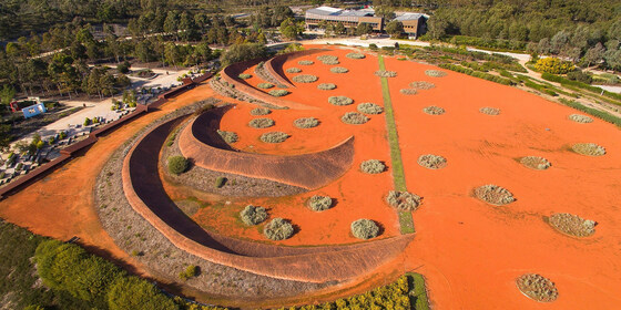
Use up the leftover food from Christmas celebrations and take in some post Christmas exercise via a relaxing visit on the Tuesday public holiday, not too far from Melbourne, to view the stunning Australian Gardens at the Cranbourne site of the Royal Botanical Gardens. Travel via public transport is possible, but a bit slow, and will involve significant walking.
GRADE | LENGTH | TYPE: Easy, up to 8 km walking around the site.
ACTIVITY DESCRIPTION: We have visited the Cranbourne site of the Royal Botanical Gardens a number of times in the past and each time there has been expansion and new developments to explore. The day will start with an exploration of the garden area followed by lunch and fellowship. Lunch will take place at the Woodlands picnic area, which is close to the main car park and offers shelter, BBQ facilities, toilets and water taps. It's recommended that a fold up chair be placed in your vehicle as a back-up option to guarantee a seat. Should Woodlands be too busy, the alternative site is the Stringybark picnic area. This will provide an opportunity to use up leftover food from Christmas.
BOOKING: By Sunday 25th December via Get Tickets.
Unsure if you've already booked? Click View my bookings.
MEETING TIME | LOCATION: 10:30am outside the Visitor Centre (in the Boon Wurrung Cafe complex). Entry to the gardens is via Ballarto Rd - if coming from Cranbourne on the South Gippsland Highway, turn right into Ballarto Rd about 500 metres past the racecourse.
MAP REFERENCE: Melway map 133 grid F10 | Google map goo.gl/maps/mHyVFk3BqhH2.
DISTANCE | TIME FROM GPO: 56 km, approximately 1 hour to drive via the Monash Freeway, 1 hour 49 minutes by public transport.
PUBLIC TRANSPORT: Take the Cranbourne line train to the Cranbourne terminus then bus #796 from the station to the intersection of Ballarto Rd and the South Gippsland Highway followed by a walk to the gardens. Capped public transport fees apply on public holidays - myki money at $6:70 Full and $3:35 for Concession and Seniors.
FOOD: Bring lunch, snacks and at least 1 litre of water and other beverages of choice. NB: You must take home all your rubbish, etc. Optional afternoon tea in the on-site Boon Wurrung Café at 4pm sharp (it closes at 4:45pm).
APPAREL | FOOTWEAR: Sunglasses, hat, sunscreen, insect repellent if you have sensitive skin, plus your camera. Comfortable walking boots/shoes and dress according to the weather forecast.
FURTHER INFORMATION: rbg.vic.gov.au/visit-cranbourne. The gardens are open from 9am to 5pm. No pets allowed.
LEADER: Garry O. | Email LeaderGarryO.thenomadsinc@mail.tidyhq.com if you have any questions.
Members can access leader contact details under Members | Leader Contacts when logged in to the website.
HOME BACK TO LIST OF EVENTS MEMBERSHIPS
