The Nomads Outdoors Group Inc.
Powered by
Past events
All events
Past events

Sep
23
2023
Past Event
Mixed Naturist 10 Pin Bowling, Eastern Suburbs of Melbourne
Box Hill
19:30 – 22:00
GOOD NEWS, WE HAVE REACHED THE MINIMUM NUMBERS. THE EVENT IS DEFINITELY GOING AHEAD. BOOK NOW BEFORE TICKETS ARE ALL SOLD.
Join us for a fun evening of nude 10 pin bowling at a location in the Eastern Suburbs of Melbourne. We have hired the entire venue. The event is open to Nomads members and visitors.
Ticket holders will receive address details of the venue by Wednesday 20th September 2023. Location given is approximate. We are only able to share the venue details, including the suburb, with confirmed ticket holders.
DINNER AFTER THE BOWLING: Some of us may like to go for dinner after the Bowling night, so we have booked a table with a local Chinese Cafe/Restaurant in Box Hill - everyone is invited to come along. The table is booked for us under the name of "Russell" from 10.20pm to midnight. You will have to wear your clothes in this venue, sorry. If you could send an email to Russell and Michael to let us know that you would like to come along that would help with the seating arrangements. Please send your email to Assistant Leader Russell.
The restaurant is Hills BBQ Noodle Shop, 586 Station St, Box Hill. There is some parking in Station St and also around the corner in Bank St. See you there.
ACTIVITY DESCRIPTION: We will meet out the front of the venue at 7.30pm if the weather is fine, or inside the foyer if it is raining. Please do not block the entrance, as other patrons may be leaving the building. We would ask that everyone is respectful of the venue staff, who are assisting us to make this event happen.
Facemasks are not required to be worn but you may wear a mask if you would prefer. Hand sanitiser will be provided.
Once introductions are completed, we will proceed to the bowling area. When advised by the Event Leader, everyone may then undress. All clothes can be left at the rear of the bowling alley. You may wish to bring a small bag for your clothes. There should be no problem with security, but we recommend that you do not bring valuables into the venue, as we are unable to take responsibility for any losses.
The time allocated for bowling is 8pm until 10pm.
Bowling shoes will be provided for all. You will each be able to select a suitable bowling ball to use during the evening, and then can join in with others at any one of the lanes. Do not worry if you are on your own, we will ensure that everyone finds a group to bowl with. You do not need to be experienced in 10 pin bowling. This is all about having fun with like minded people.
Depending on the number of bowlers at each lane, you can typically expect to complete up to two games.
There will be a small competition with prizes which will be awarded based on the individual scores of the first game.
In order to maintain everyone's privacy, please note that no photographs will be permitted except as advised by the Event Leader on the night. Phones are not to be used during the evening, and we thank you for assisting us with this.
Please see the Event Leader if you have any concerns.
It would be appreciated if everyone could promptly depart the venue at 10pm. We would welcome the assistance of a few people to help the organisers with packing up after the night.
BOOKING: By 1pm on Saturday 23rd September 2023. To register, click on Get Tickets.
Tickets may sell out for this event, so book early. Tickets will be allocated on a "first come, first served" basis. No tickets will be available for purchase at the venue. Ticket prices for this event are the same for Nomads members and visitors to cover the cost of hire of the venue.
Please note that the event will be cancelled and full refunds will be made if we are unable to achieve sufficient numbers by 7th September 2023, as we need to fully cover the cost of hiring the venue.
No refunds on tickets will be available after 7th September 2023, except for inability to attend due to illness including Coronavirus, or if the event is cancelled by the Event Leader.
If the event is a sellout, a wait list will be created.
Unsure if you've already booked? Click View my bookings.
MEETING TIME | LOCATION: 7.30pm at the entrance to the venue, ticket holders will receive address details by Wednesday 20th September 2023.
DISTANCE | TIME FROM GPO: 20-25 km, approximately 30 minutes to drive, or 1 hour 10 minutes by public transport and walking.
PUBLIC TRANSPORT: The venue is accessible by public transport. Approx 50min train journey from Flinders Street railway station, followed by a 30min walk. More precise public transport details will be provided to ticket holders by Wednesday 20th September 2023.
FOOD: You may bring your own drinks to the venue. Alcoholic drinks for personal consumption are permitted in the supper room adjoining the bowling area, but not in the room where we are bowling. No glass, please for safety, and ensure that no drinks at all are taken into the bowling lane area.
APPAREL | FOOTWEAR:
This is a naturist event, not clothing optional, so everyone is asked to be naked while bowling. The only exception is for women during their periods, who may wear a bikini bottom or similar.
Bowling shoes will be provided and must be worn.
Please bring your own towel to sit on for hygiene reasons.
LEADER: Michael J. | Email the Leader if you have any questions.
Members can access leader contact details under Members | Leader Contacts when logged in to the website.
HOME BACK TO LIST OF EVENTS MEMBERSHIPS

Sep
17
2023
Past Event
George Bass Coastal Walk **POSTPONED
Punch Bowl Road
11:00 – 16:00
Please note: This event has been postponed due to illness of the leader.
Follow the route of Bass’ voyage of discovery along the Victorian coastline.
GRADE | LENGTH | TYPE: Medium grade, 15 km walk from San Remo to Kilcunda (and back on the same trail).
ACTIVITY DESCRIPTION: The George Bass Coastal Walk offers panoramic coastal views from a narrow winding path along cliff tops, with expansive views of the turbulent Bass Strait dipping down to secluded beaches.
BOOKING: This event has been postponed to a future date.
MEETING TIME | LOCATION: 11am at the car park at the end of Punch Bowl Rd, San Remo. Punch Bowl Rd is on the way to Phillip Island - turn left from Phillip Island Rd (B420) 2 km after the B460 junction.
MAP REFERENCE: Melway map X912 grid Q11 | Google Map: goo.gl/maps/j6bSiQzYrgNaAVmJ7.
DISTANCE | TIME FROM GPO: 122 km from Melbourne - allow 1.5 hours.
FOOD: Bring your own lunch and at least 1 litre of water.
APPAREL | FOOTWEAR: Sturdy walking footwear, dress for the weather forecast and bring a raincoat just in case!
LEADER: Cahal F. | Email the Leader if you have any questions. Members can access leader contact details under Members | Leader Contacts when logged in to the website.
HOME BACK TO LIST OF EVENTS MEMBERSHIPS
Sep
17
2023
Past Event
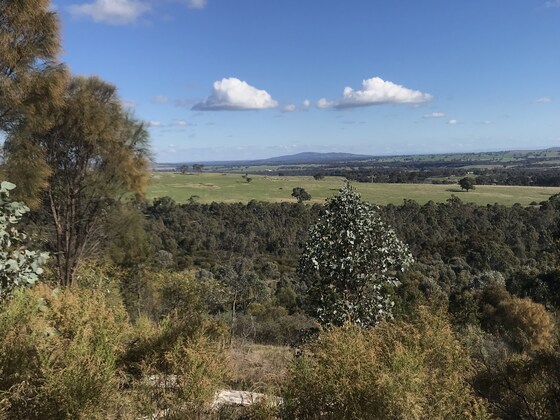
Naturist Walk, Kangaroo Flat, South Bendigo, Views and Wildflowers
MacDonald's Kangaroo Flat
11:00 – 16:00
A pleasant naturist walk to the top of a forest ridge, just south of Bendigo for great views to the south. Lunch at the top and hopefully some wildflowers to see along the way. Bendigo generally has more sunny weather than Melbourne and its Springtime happens earlier than the Spring in Melbourne.
Please Note: This walk has been postponed from Saturday 9th September to Sunday 17th September because of the freezng weather forecast on the 9th, only 14C max.
GRADE | LENGTH | TYPE: Moderate 6.5 km circuit walk. We have designed the walk to be not too long so that we will have time to enjoy the scenery & the wildflowers, and get our legs back in shape after the winter break. Nevertheless there is a pleasant climb to the top of the ridge.
ACTIVITY DESCRIPTION: We will first meet for a coffee and catch up at Kangaroo Flat MacDonalds. From there we will car pool or drive your own car approximately 7 km (10 mins) to the start of the walk on the edge of the forest. Clothes can be removed soon after the start of the walk as we are walking in a remote section of the forest. We will stop for a leisurely lunch on the top of the range. From here we continue for a bit further along the ridge-top and then circle back through the backcountry forest to the cars. We then plan to return to Kangaroo Flat to the Windermere Hotel bistro for cool drinks, coffee and snacks. If you wish, you can stay on for dinner which starts at 5.30pm. If you happen to be travelling by public transport, it is an 8 min (550m) walk to the train station. For details see the Public Transport section below.
BOOKING: Preferably by Thursday 14th September. To register click on Get Tickets.
Unsure if you've already booked? Click View my bookings.
MEETING TIME | LOCATION: 11 am at MacDonald's, 166 High St, Kangaroo Flat (a southern suburb of Bendigo). High St is also the Calder Highway into Bendigo. There is a good sized parking lot at MacDonalds. If that is full there is another parking lot next door at Aldi.
MAP REFERENCE: Melway map X909 grid D4 | Google map https://goo.gl/maps/nS72rptZnUP8kUQm6
AFTERNOON REFRESHMENTS LOCATION: Windermere Hotel bistro. The bistro is towards the rear of the hotel. The hotel is at 112 High St, Kangaroo Flat, 200 metres north of MacDonald's. The best parking is in the Champions IGA in Dunlop Lane behind the hotel. The hotel serves meals in the bistro starting at 5.30pm.
DISTANCE | TIME FROM GPO: 145 km, approximately 1 hour 40 minutes via Calder Fwy/M79.
PUBLIC TRANSPORT: You can catch the V/line train leaving Southern Cross at 9.05am, arriving Kangaroo Flat railway station at 10.50am. This is a very pleasant relaxing trip. From the station it is a 9 min, 750m walk to MacDonald's. There are public toilets along the way in the Kangaroo Flat Native Botanic Gardens on the left hand side in Station St as you walk to the cafe at 124 High St.
For the return trip to Southern Cross there is a V/line train leaving at 4.29pm. Trains then depart regularly every hour to 1.5 hours after that, until 9.43pm.
FOOD: Carry lunch, snacks and a litre of water. You can buy sandwiches and rolls at the meeting place cafe if you need to. However it may be better to bring your lunch from home so that we don't overwhelm the cafe.
APPAREL | FOOTWEAR: Comfortable walking boots/shoes, hat, sunscreen, dark glasses. Shorts will be needed for the start and end of the walk. You may need a light windproof jacket when we stop for lunch. However let's hope there is no wind!
LEADERS: Joint leaders Bruce Mc and Russell W. | If you have any questions email LeaderRussellW.thenomadsinc@mail.tidyhq.com. From this email address questions will be sent to both leaders.
Members can access leader contact details under Members | Leader Contacts when logged in to the website.
HOME BACK TO LIST OF EVENTS MEMBERSHIPS
Sep
16
2023
Past Event
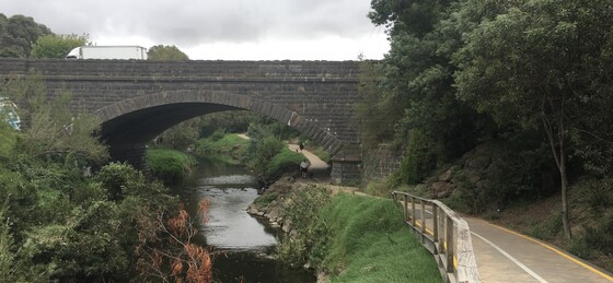
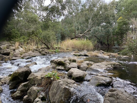
Merri Creek & Inner Circle Rail Trail Walk
Coburg Lake Reserve
10:15 – 16:30
Enjoy a pleasant day walking along the picturesque Merri Creek on a moderate walk through the inner northern suburbs of Melbourne. The walk includes some hidden gems as well as a good array of birdlife, the result of many years of replanting indigenous vegetation. The often-shady trail hugs the creek intimately, with wetlands, cable suspension bridges, parks and veggie gardens. We then pick up the Inner Circle Rail Trail, with its remnants of the old inner circle rail line which once connected North Fitzroy to Parkville and is now a linear park.
This event suits those who enjoy nature, keen to learn more about the history of Melbourne and to train buffs!
GRADE | LENGTH | TYPE: Moderate, approximately 12.5 km point-to-point walk on mostly flat paths.
ACTIVITY DESCRIPTION: Our walk starts at the very popular Coburg Lake Reserve, where the Merri Creek will be waiting for us. After briefly exploring the lake, we make our way south along the Merri Creek Path where we will closely follow the creek over a number of bridges, parklands, wetlands and reserves. We will stop for lunch beside the Merri Creek to enjoy the views and sounds of the creek.
After crossing the old trestle railway bridge, we will then pick up the Inner Circle Rail Trail, a linear reserve remaining from what is left of the abandoned railway line that stopped running in 1981 after a long history of service. The trail now serves as a shared bicycle path connecting the Merri and Moonee Ponds Creeks. We will discuss the history of the line and your leader will point out the locations of the old stations and the existing infrastructure that remains today.
Moving further west our walk concludes at Jewell Station, where those who travelled by car will take the train back to the beginning point of the walk.
The event leader will also cover the history of a number of key attractions along the way:
History of the Merri Creek and importance to Indigenous people
The use of bluestone and history of Pentridge Prison
Harding Street Bridge
Ceres Community Park
Russian Orthodox Church
History of the inner circle rail corridor
Explore the abandoned rail lines, stations, signals and power transmission of the old line
Explore the hand operated signalling and railway crossings.
This is intended to be a public transport friendly event where the start and end points will be accessible by train and tram.
BOOKING: By Thursday 14th September. To register, click on Get Tickets.
Unsure if you've already booked? Click View my bookings.
FURTHER INFORMATION: Merri Creek Brochure.
MEETING TIME | LOCATION: 10:15am | Lake Grove Carpark, Coburg Lake Reserve, Coburg North.
MAP REFERENCE: Melway map 17 grid H10 | Google map goo.gl/maps/s29AJAqkwh7ejgU87.
DISTANCE | TIME FROM GPO: 9.5 km, approximately 30 minutes to drive, 25-35 minutes by public transport. There is car parking available at the Lake Reserve in Lake Grove free of charge. You will need a Myki card to return back to your car by public transport, either by tram or train.
PUBLIC TRANSPORT:
By Train: Take the Upfield train line from the CBD and get off at Batman Station. Walk east for 4 minutes to the starting point. The conclusion of the walk will be at Jewell station (same train line) where you can return back to the CBD.
By Tram: Take the Route 19 Tram from Elizabeth Street CBD. Get off at Stop 37 (Gaffney Street/Sydney Road). Walk 2 minutes east to the starting point. The conclusion of the walk will cross the same tram line (Stop 18) where you can return back to the CBD.
FOOD/DRINKS: Carry lunch, snacks and at least 1 litre of water. Also carry sunscreen and a hat. Bring your Myki card for the return trip by tram or train for those travelling by car back to the starting point.
APPAREL | FOOTWEAR: Comfortable walking boots/shoes and dress according to the weather forecast. Ensure your shoes are waterproof as some of the paths may be wet or muddy if it has rained heavily prior to the event.
LEADER: Jason T. | Email the Leader if you have any questions.
Members can access leader contact details under Members | Leader Contacts when logged in to the website.
HOME BACK TO LIST OF EVENTS MEMBERSHIPS
Sep
10
2023
Past Event
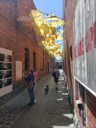
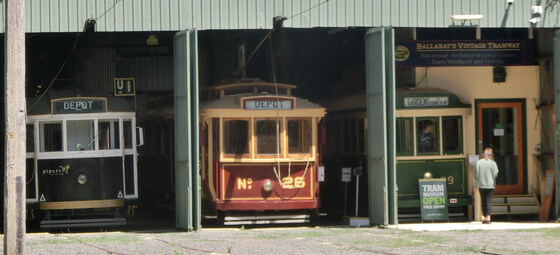
2023 Ballarat Foto Biennale - Walking Tour & Pub Lunch
Southern Cross
09:00 – 18:30
Pound the streets in the historic inner precinct of Ballarat, visiting the multiple locations hosting exhibitions for the 2023 International Foto Biennale. Travel via public transport is possible. First action will be to collect FREE maps of the displays (indoor and outdoor) at the Biennale Office on Lydiard Street (just up the street from the Station); which is also a venue for some of the smaller exhibitors.
GRADE | LENGTH | TYPE: Easy, approximately 6 km, circuit walk on flat paths.
ACTIVITY DESCRIPTION: Ballarat is home to the National Centre for Photography (NCFP) housed in the old Union Bank building on Lydiard Street North. It's the base for the team behind BIFO.
The Ballarat International Foto Biennale was founded in 2005 and attracts significant international and Australian photographers as one of Australia's pre-eminent photographic festivals. The multiple exhibitions, both free and ticketed, are housed in various historic buildings, laneways and cafes. Full details of the program are available online at ballaratfoto.org. Most exhibitions are open daily from 10am to 5pm.
The featured ticketed events this year include an international plus a local exhibition that may be of interest to NOMADS Members:
Instant Warhol (56 images) at the Art Gallery of Ballarat (a BIFB exclusive), and
Cruising For A Bruising - an exhibition of work by Wiradjuri queer photographer, Kyle Archies Knight, at the Mining Exchange.
Check ballaratfoto.org for details of purchasing 1-day passes to visit the multiple ticketed events.
BOOKING: By Thursday 7th September. To register, click on Get Tickets.
Unsure if you've already booked? Click View my bookings.
MEETING TIME | LOCATION: 10:45am at the Ballarat Railway Station, Lydiard Street North. Travel options are (1) by train (see details below) or (2) driving and parking on the fringes of the Ballarat CBD, as on-street parking in the CBD is time limited and fees may be payable.
MAP REFERENCES:
Southern Cross Station - Melway map 1A grid A7 | Google map goo.gl/maps/s6DUsRG8CWz2K97eA
Ballarat Station - Melway map 611 grid A12 | Google map goo.gl/maps/KjS3JEEYfng9UvaE7.
DISTANCE | TIME FROM GPO: 114 km, approximately 1 hour 25 minutes to drive, 1 hour 29 minutes by public transport.
PUBLIC TRANSPORT: The trip is on the train departing Southern Cross Station at 9:14am arriving at 10:43am. It's suggested that we gather in the first carriage (North Melbourne end). Return trains depart Ballarat every hour, for example: 3:20pm, 4:20pm, 5:20pm and 6:20pm. Weekend fares for Myki money are capped at $7.20 (Full) and $3.60 (Concession & Seniors) per day.
FOOD: A booking will be made for a 12:30pm lunch at Sporting Globe Bar & Grill, 201 Mair Street, Ballarat (opposite the Art Gallery of Ballarat) for those interested. Otherwise do your own thing in between visiting exhibition sites.
APPAREL | FOOTWEAR: Comfortable walking shoes and dress according to the weather forecast.
LEADER: Garry Oliver | Email LeaderGarryO.thenomadsinc@mail.tidyhq.com if you have any questions.
Members can access leader contact details under Members | Leader Contacts when logged in to the website.
Image: Garry Oliver
HOME | BACK TO LIST OF EVENTS | MEMBERSHIPS
Sep
05
2023
Past Event
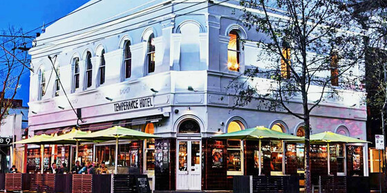
Social Night - Temperance Hotel
426 Chapel St
19:00 – 21:00
Our regular monthly social night - this month at the Temperance Hotel.
GRADE: Social.
ACTIVITY DESCRIPTION: The Nomads hold a social night each month, where members and guests can enjoy a meal, talk about upcoming events, compare notes on past activities and float ideas on events they would like to see run. New members are especially invited to our social nights as an orientation to Nomads activities.
Tuesday night is Parma Night at the Temperance Hotel - $20 parmas. Or you can order from their regular menu.
BOOKING: By Monday 4th September. To register, click on Get Tickets.
Unsure whether you have booked? Click View my bookings.
MEETING TIME | LOCATION: 7pm at the Temperance Hotel, 426 Chapel St, South Yarra.
MAP REFERENCE: Melway map 2L grid J8. Google map goo.gl/maps/8jh5oWmraU2Vn1BE6.
PUBLIC TRANSPORT and PARKING: The Temperance Hotel is well served by public transport, but parking is limited. Suggested options:
Tram 72 to stop 30 (Prahran Market / Commercial Rd)
Tram 6 to stop 30 (Prahran Station / High St)
Tram 58 to stop 128 (Chapel St / Toorak Rd)
Tram 78 to stop 48 (Wilson St / Chapel St)
Train: Cranbourne, Pakenham, Frankston or Sandringham line to South Yarra
LEADER: Garry O. | Email LeaderGarryO.thenomadsinc@mail.tidyhq.com if you have any questions.
Members can access leader contact details under Members | Leader Contacts when logged in to the website.
HOME BACK TO LIST OF EVENTS MEMBERSHIPS
Sep
03
2023
Past Event
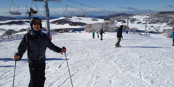
Ski Week at Falls Creek
Cosela Alpine Club
03 Sep 2023 13:00 – 10 Sep 2023 10:00
Sunday 3rd to the 10th September. Note: Gay Ski Falls Creek is on from the 1st to the 10th September.
A full week of cross-country skiing, downhill skiing and/or snowboarding, staying in a cosy lodge at Falls Creek. Stay the full week, or part thereof.
GRADE | LENGTH | TYPE: Your choice (choose slopes and equipment to match your skills) – cross-country skiing, downhill skiing and/or snowboarding.
ACTIVITY DESCRIPTION: A full week, or part thereof, ski trip to Falls Creek is planned for dates to be confirmed depending on accommodation availability. We will be staying at the cosy Cosela Alpine Lodge, which provides ski-in ski-out access from Wombats Ramble with no oversnow transport requirements. This will be a cross-country ski, downhill ski and/or snowboard week leaving Melbourne on Sunday and leaving Falls Creek the following Sunday.
BOOKING: Please register your interest by Monday 22nd May, or ASAP. Accommodation will be booked once bed availability and size of the group is known. To register your interest, click on Get Tickets.
Unsure if you've already booked? Click View my bookings.
FURTHER INFORMATION: www.cosela.com.au/Winter/index.html.
MEETING TIME | LOCATION: Sunday afternoon, Cosela Alpine Lodge, Falls Creek.
MAP REFERENCE: Melway Map X922 grid H10 | Google map goo.gl/maps/V7fBUEiNBb62.
GETTING THERE: There are coach services from Melbourne, Mt Beauty and many other locations to Falls Creek. There are long-term parking facilities in Mt Beauty if you don’t wish to take your car up the mountain. If driving, take the Hume Freeway (M31) to Wangaratta then the Great Alpine Road (B500), turning off to Mt Beauty. On arrival at Falls Creek you should request to unload your luggage at the steps beyond the CFA station, which is lit at night. As you are staying at Cosela, you don't need oversnow transport. After unloading, you will return to the attendant to be directed to a parking place. Cosela Lodge can then be reached by travelling up the steps and across Snowgum Lane (see map at www.cosela.com.au/Winter/Map.html).
DISTANCE | TIME FROM GPO: 391 km, 4.5 hours.
FOOD: It's advisable to bring food for the period of your stay; group catering arrangements will be organised after registration. Breakfast cereal, milk, bread, jam, condiments, tea and coffee are provided by the lodge. There’s a local food store for last minute supplies and oversights.
COST: The accommodation cost for September is $102 per Nomads member per night for Sunday through Thursday, and $246 for Friday plus Saturday night (i.e. $123 per night, but payment is required for both nights if either is required). You can come for the full time or part thereof. Get a ticket to indicate your intention to attend. The leader will then contact you to confirm dates and times, and to organise payment. Not a Nomads member? Purchase a temporary one-month membership before getting your tickets (cost $8).
APPAREL | FOOTWEAR: Bring sheets and pillowcases, towel, washer and toiletries, plus ski gear to suit all possible conditions (or hire it in Mt Beauty or Falls Creek). Don’t forget warm, comfortable clothing for after-ski activities. If driving you will be required to carry chains (these can be hired in Mt Beauty), and you should ensure your radiator has antifreeze.
LEADER: Les B. | Email LeaderLesB.thenomadsinc@mail.tidyhq.com if you have any questions.
Members can access leader contact details under Members | Leader Contacts when logged in to the website.
HOME BACK TO LIST OF EVENTS MEMBERSHIPS
Sep
02
2023
Past Event
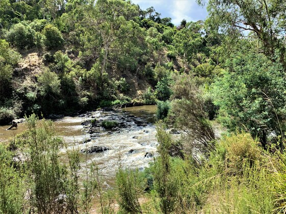
Werribee River & Lollipop Creek to Wyndham Vale Station Ramble
Southern Cross Station
09:15 – 16:00
Enjoy a gentle semi rural urban ramble alongside the Werribee River, and parks, before joining the Lollipop Creek, and on to Wyndham Vale Station.
GRADE | LENGTH | TYPE: An easy 12 km point-to-point walk with public transport links.
ACTIVITY DESCRIPTION: This walk from Werribee Station follows the Werribee River up-stream passing by natural vegetation including some impressive river red gums. Circuiting Presidents Park and floodway, offering a combination of parkland and natural landscapes to enjoy, we cut through Ballan and Greens Roads briefly to meet up with the Lollipop Creek trail. Making our way up-stream to Manor Lakes Linear Park, which takes us into the Lollipop Creek Reserve, with the opportunity to take in some of the re-vegetation and conservation measures along the creek and surrounding wetlands. The croaking of frogs and chirping of birds are likely to be often heard. From there, it is only a short walk on to Wyndham Vale Station for a homeward train, normally running every 20 minutes.
NB. For this event, trains appear to be running normally as today (Friday).
BOOKING: By Thursday 31st August. To register, click on Get Tickets.
Unsure if you've already booked? Click View my bookings.
MEETING TIME | LOCATION: Meet at Flinders Street 9.15am (usually platform 9, but check monitors upon arrival) for 9.27am Werribee train, front carriage, alighting at Werribee Station at 10:16am for walk departure at 10.20am, or meet the group en route by arrangement with the event leader.
MAP REFERENCE: Melway map 43 grid E9 | Google map goo.gl/maps/bCGTVY7pXX72.
DISTANCE / TIME FROM GPO: The walk commences at Werribee Railway Station which is 35 km and 45 minutes by train from the city. Our return journey takes 35 minutes from Wyndham Vale Railway Station which is 40 km from the city.
TRANSPORT: Access to and from this walk is by public transport only. We will travel to Werribee Railway Station in the front carriage departing Flinders Street Railway Station at 9.27am, arriving at Werribee at 10.16am, or you may choose to meet the group en route by arrangement with the event leader. For the return journey trains depart Wyndam Vale Railway Station (Geelong Train) every 20 minutes. All travel is within Myki zones 1 & 2 with weekend daily caps of $7.20 full fare, $3.60 concession and free for seniors.
FOOD: Carry lunch, snacks and water for your needs throughout the day.
APPAREL | FOOTWEAR: Wear comfortable walking boots/shoes and dress to meet the forecast weather conditions.
LEADER: Michael C. Email LeaderMichaelC.thenomadsinc@mail.tidyhq.com if you have any questions.
Members can access leader contact details under Members->Leader Contacts when logged in to the website.
HOME BACK TO LIST OF EVENTS MEMBERSHIPS

Aug
29
2023
Past Event
500 Cards - Online via Trickster Cards
19:00 – 21:00
Play a game or two of 500 cards online via the Trickster Cards website, with fellow Nomads 500 card players.
TYPE: Social
ACTIVITY DESCRIPTION: Enjoy playing a social game of 500 cards, in groups of four, from anywhere in Australia or even overseas, from the comfort of your own home, while enjoying your favorite beverage or nibbles. You will be able to see and hear the other players and enjoy the banter of your fellow Nomads members.
BOOKING: By Monday 28th August. To register click on Get Tickets. You will be e-mailed the link to play the game prior to 7pm on Tuesday 29th August.
Unsure if you've already booked? Click View my bookings.
MEETING TIME | LOCATION: At 7pm click on the link that will be e-mailed to you on Tuesday prior to the game.
LEADER: Stephan C. | Email LeaderStephanC.thenomadsinc@mail.tidyhq.com if you have any questions.
Members can access leader contact details under Members | Leader Contacts when logged in to the website.
HOME BACK TO LIST OF EVENTS MEMBERSHIPS
Aug
27
2023
Past Event
Wendouree to Ballarat - Train and Walk Experience ** Now 27 August
Wendouree Station
09:00 – 17:00
A pleasant Sunday walk from Wendouree Railway Station to Ballarat Station via the Ballarat Tram Depot and Lake Wendouree.
NOTE: This event has booked out. Apologies if you missed out - but it is hoped to run it again in the future.
GRADE | LENGTH | TYPE: Easy 7 km walk into Ballarat along gravel and bitumen tracks.
ACTIVITY DESCRIPTION: An easy walk to visit the Botanical Gardens and view a line of Australian Prime Ministers' statues before a visit to the Ballarat Tram Depot (Ballarat Tramway Museum) for an informative history of Ballarat trams. Have a picnic lunch beside Lake Wendouree or at the nearby cafe/restaurant. An easy walk back to central Ballarat via the imposing cricket ground stadium and historical buildings. A 3:14pm departure from Ballarat Station should arrive back at Southern Cross at 4:48pm.
BOOKING: By Friday 25th August. To register, click on Get Tickets.
Unsure if you've already booked? Click View my bookings.
MEETING TIME | LOCATION: 9am at Southern Cross Station, in time to catch the Wendouree train that departs at 9:14am. We'll travel in the front carriage. Alternatively, meet the train when it arrives at Wendouree Station at 10:51am.
PUBLIC TRANSPORT: This event is designed to use public transport to travel to the start, and from the end of the walk. All travel will be within the Myki zone, so you will require a valid Myki card to travel.
Outbound: the Wendouree train that departs from Southern Cross Station at 9:14am arrives at Wendouree Station at 10:51am.
Return: trains depart hourly for Southern Cross from Ballarat Station, for example at 3:14pm, 4:14pm, 5:04pm and 6:14pm. The journey takes 1 hour 34 minutes.
MAP REFERENCE:
Southern Cross Station: Melway map 1A grid A7 | Google map: goo.gl/maps/eZyC4YRk3dDhQq51A
Wendouree Station: Melway map X909 grid A11 | Google map: goo.gl/maps/tGN7yMLurs3cthVm7
COST: The Weekend Saver cap now applies for travel anywhere within Victoria, hence you will pay $7.20 full, or $3.60 concession, for the entire trip (with no additional charge for any other trips you make the same day).
FOOD: Carry lunch (unless you plan to get lunch at the cafe), snacks and some drinking water.
APPAREL | FOOTWEAR: Face mask, hand sanitiser, comfortable walking boots and dress according to the weather forecast.
LEADER: John T. | Email LeaderJohnT.thenomadsinc@mail.tidyhq.com if you have any questions.
Members can access leader contact details under Members | Leader Contacts when logged in to the website.
HOME BACK TO LIST OF EVENTS MEMBERSHIPS
Aug
26
2023
Past Event
Lower Templestowe to Eltham Ramble
Templestowe Hotel
11:00 – 16:00
Favourite country of Heidelberg School of painters, a very pleasant Saturday walk from Lower Templestowe, through parklands trail following the Yarra River up-stream, before joining the Diamond Creek parklands trail up to Eltham shops/station.
GRADE | LENGTH | TYPE: A Moderate 12 km walk between Lower Templestowe and Eltham with a few inclines from time to time.
ACTIVITY DESCRIPTION: Catching the 905 bus from CBD (optional) to Omar St/Parker Street stop just before the Templestowe Hotel, Lower Templestowe for 11.10am start (meet in front of the hotel). We walk into Finn's Reserve taking the Yarra Trail, we continue into Westerfold and Candlebark Parks, following the Yarra upstream, before crossing it into Diamond Creek country, taking its trail through picturesque parks past the mini rail, and nature reserves up-stream to Eltham for optional social in cafe/bar before catching a city bound train homewards.
BOOKING: By Friday 25th August. To register click on Get Tickets.
Unsure if you've already booked? Click View my bookings.
MEETING TIME | LOCATION: 11.10am in front of Templestowe Hotel, Parker Street, Lower Templestowe.
MAP REFERENCE: Melway map X33 grid C4 | Google map goo.gl/maps/64X3eBAxq6xtWPnu6.
DISTANCE | TIME FROM GPO: 35 km, approximately 1/2 hour from CBD driving to Templestowe. As we are using a Hurstbridge/City train to get home later, it may pay to take the bus option from the city out to Templestowe.
PUBLIC TRANSPORT: I would suggest picking up the 905 bus, departing CBD (e.g. King St/Lonsdale St at 10:20am) to get you to Templestowe Hotel, Parker St, Lower Templestowe for 11.10am (bus stop Omar St/Parker St). I'll be picking this bus up from Johnston/Hoddle Streets bus stop at 10.37am. Homeward train later from Eltham, city bound every 20 minutes.
FOOD: Carry alfresco lunch, snacks and plenty to drink.
APPAREL | FOOTWEAR: Comfortable walking boots/shoes, wet weather gear, and dress for warmth according to the weather forecast.
LEADER: Michael Cowan | Email LeaderMichaelC.thenomadsinc@mail.tidyhq.com if you have any questions.
Members can access leader contact details under Members | Leader Contacts when logged in to the website.
HOME BACK TO LIST OF EVENTS MEMBERSHIPS
Aug
20
2023
Past Event
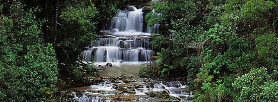
Masons Falls via Boundary Track and Wallaby Trail (Kinglake)
11:00 – 16:00
A circuit walk in the North East of Melbourne, near Kinglake.
GRADE | LENGTH | TYPE: Easy/Mod 6 km circuit walk - total rise 190m.
ACTIVITY DESCRIPTION: This is a great short walk with beautiful views of Masons Falls and peaceful scenery with lots of wildlife to spot. The track is equal part in slopes and flats, with a quite steep slog back to the cars, so there are some moderate challenges in sections good for all fitness levels.
The track can get muddy after the rain, so be sure to set out with good footwear if there's been recent rainfall.
BOOKING: By Friday 18th August. To register, click on Get Tickets.
Unsure if you've already booked? Click View my bookings.
MEETING TIME | LOCATION: 11am at Blackwood Picnic Area, Kinglake West VIC 3757
PUBLIC TRANSPORT: Public transport is not viable.
MAP REFERENCE: Melway map X910 N 11 | Google map: https://goo.gl/maps/A7ZLcvjgQaP48uwZA
FOOD: Carry lunch, snacks and a litre of water.
APPAREL | FOOTWEAR: Comfortable walking boots and dress according to the weather forecast.
LEADER: Richard C. | Email LeaderRichardC.thenomadsinc@mail.tidyhq.com if you have any questions.
Members can access leader contact details under Members | Leader Contacts when logged in to the website.
HOME BACK TO LIST OF EVENTS MEMBERSHIPS