The Nomads Outdoors Group Inc.
Powered by
Past events
All events
Past events
Apr
21
2024
Past Event
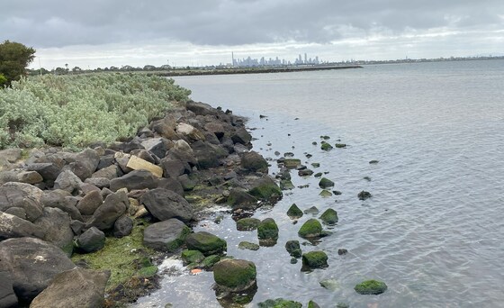
Altona to Williamstown walk, ferry to St Kilda
Altona Railway Station
10:00 – 16:30
A pleasant walk along the Bay Trail West following part of the western shoreline of Port Phillip Bay.
GRADE | LENGTH | TYPE: Easy 12.7 km point to point walk on flat paths (shared bike trail).
ACTIVITY DESCRIPTION: After we arrive at Altona station we will walk to the Rockabye Candy Cafe for morning tea whilst we wait for other Nomads to arrive. At 10:45am we will begin our walk by heading off to Altona Beach where we can walk out along the new 310m Altona Pier (opened Jan 22nd 2024). The old 1800's timber pier was demolished after storm damage. Following the Bay Trail (West) and The Esplanade we soon pass through the Altona Coastal Park and across the Kororoit Creek. We pass the Kororoit Creek Historic Fishing Village, through the Paisley-Challias Wetlands and Domwell's Round. Depending on time and weather, we can stop for a swim at Williamstown Beach and a drink at a kiosk, if open. Continuing on, we can make a detour and visit the Williamstown Botanic Gardens before passing the Fort Gellibrand Rock Pools and passing through the Point Gellibrand Coastal Heritage Park and Lookout. From here we walk along Nelson Place to Gem Pier to catch the 4pm ferry to St Kilda. For anyone returning by train, it is an 800m/11 min walk to the Williamstown Station.
BOOKING: By Friday 19th April. You also need to book the ferry service if you wish to take that.
NOMADS: To register to attend, click on Get Tickets.
FERRY: If planning to catch the ferry, book your ferry ticket at least a few days before this event direct from St Kilda Ferry for the 4:00pm service to St Kilda.
Unsure if you've already booked for this Nomads event? Click View my bookings.
FURTHER INFORMATION: ptv.vic.gov.au St Kilda Ferry
MEETING TIME | LOCATION: 10am at Altona Railway Station - if you like breakfast/morning tea or by 10:45 at the Rockabye Candy Cafe, 32-34 Pier Street, with no morning tea (280m/5min walk from the station).
MAP REFERENCE: Melway map 54 grid H11 | Google map goo.gl/NJYifwsM1nEv7ZUx9.
DISTANCE | TIME FROM GPO: 26 km, 29 minutes by train.
PUBLIC TRANSPORT: Train Departs Flinders Street at 09:27. Arrives ALTONA at 09:56. (Werribee Line train via Southern Cross) - for Breakfast/Morning Tea. Next service Departs Flinders Street at 09:47, Arrives 10:16 or Depart Flinders Street at 10:07, Arrive 10:36 - No morning tea. If not taking the ferry option - trains to Flinders Street depart Williamstown Station every 20 minutes at 16, 36 and 56 minutes past the hour (28 minute trip).
FARES: Train - Myki: Full $7.20; Concession $3:60; Seniors Free. St Kilda Ferry: Adult $22.00 Concession $20.00
FOOD: Carry lunch, snacks and a litre of water. Drinks and snacks are available on the ferry. Kiosk at Williamstown Beach - if open.
APPAREL | FOOTWEAR: Comfortable walking boots/shoes and dress according to the weather forecast. Maybe bathers and towel if we have time to stop for a swim.
LEADER: Paul K. | Email LeaderPaulK.thenomadsinc@mail.tidyhq.com if you have any questions.
Members can access leader contact details under Members | Leader Contacts when logged in to the website.
HOME BACK TO LIST OF EVENTS MEMBERSHIPS

Apr
13
2024
Past Event
Naturist bushwalk. Views from the Range, Frog Paradise and Cow Swamp. Opt'l BBQ & Overnight on a farm near Lancefield
Lancefield
13 Apr 2024 10:15 – 14 Apr 2024 16:00
This event is now fully booked for Overnight Tickets. We have also had to close the Waitlist for Overnight stays as there are still 4 people on the Waitlist. Sorry we can't help you out this time.
There are still 3 day-walk tickets available.
_________________
This is a weekend and bushwalk for naturists. The walk is of medium difficulty through some fairly untouched and picturesque bushland on a neighbouring farm. As we climb gradually up the hill there are great views into the valley. We then cross into a neighbouring property where the frogs are VERY noisy - Frog Paradise. After that we continue on along an interesting creek, past Cow Swamp to get some more good views on the way back to the cars. If the day is hot we could go for a swim in the waterhole, or if cold, a soak in the hot spa or a warm-up in front of the large open fire.
In the evening we will be able to relax with a BBQ dinner, spa, massage, and socialising around an open fire.
GRADE | LENGTH | TYPE: Medium, approx 6 km naturist circuit walk. There will be walking through grassy paddocks, along sheep and kangaroo pads and along private 4WD tracks. The hills are moderate and not that steep.
ACTIVITY DESCRIPTION:
SATURDAY WALK: This walk is for naturists. We will meet and unload the cars at the overnight farmhouse anytime between 10.15am and 10:40am. Hot drinks and nibbles will be available until 11.10am. We will then have a briefing for the day around 11.40am and do a short car pool to the start of the walk. Lunch will be eaten at a good spot along the way when we get hungry. After lunch we will continue on for a bit to get more views and then circle around to get back to the cars to return to the farmhouse. If the day is hot we can then go for a nude swim in the lovely Mollison Creek swimming hole, or if cool have a soak in the hot tub. There will be drinks and snacks available at the farmhouse after the walk. It is planned to start the BBQ around 6pm.
OVERNIGHT: Optional evening BBQ, overnight, breakfast and lunch at the farmhouse. After the Saturday walk we have been invited back for further naturist socialising at the very comfortable farmhouse with its great open fire. There will also be a spa and massage tables to use.
SLEEPING: For those staying overnight, there is floor space for 14 people in the house. There is carpeted floor space in the library, lounge room and dining room - please BYO sleeping bag, sleeping mat/lilo, pillow etc. There is a spare double air mattress, a single air mattress, one spare doona, some blankets, a few sleeping bags and a couple of spare foam sleeping mats at the property. Or if you like, you can put up your tent on the back lawn. There is also room for campervans etc.
BBQ: BYO meat and drinks. Basic salads and bread will be supplied. Dinner desserts or morning tea snacks would be appreciated.
TOWELS: Please BYO towels, about 3 or 4 of them.
1. for sitting on. 2. for the massage table. 3. for your shower or spa. 4. after swimming.
BREAKFAST: Breakfast is supplied, including eggs and bacon, cereal, toast and spreads, tea and coffee, and for Sunday lunch there are always plenty of leftovers from the night before.
SUNDAY MORNING SHORT WALK: For those who would like a further walk, we will arrange a short walk either to the Gorge, along picturesque Mollison Creek or elsewhere in the area. This will be followed by lunch to eat up the spare food.
BOOKING: By Wednesday 10th April. To register, click on Get Tickets. Choose the ticket that provides the options you wish to participate in.
RSVP FOR OVERNIGHT ACCOMMODATION: If you wish to stay overnight, you will need to SEND AN EMAIL TO COLIN, our farmhouse host, on LeaderColinP.thenomadsinc@mail.tidyhq.com to book your accommodation. Please state what accommodation you would like - floor, tent or campervan. Please also include a contact phone number.
Sleeping places in the house are limited to 14.
The number of people staying overnight is limited to 22 so that we can all sit down to eat inside the house.
There is no limit on tents and campervans.
Unsure if you've already booked? Click View my bookings.
COST: There are two ticket types available for this event. Please choose the ticket that suits your wishes.
1. Walk & overnight with bbq, spa, massage, breakfast: Nomads members $30 | Non-members $35
2. Walk only: Nomads members $0 | Non-members $5
The cost of the overnight tickets covers the cost of a spa for all those staying overnight. For Day Walkers who would like to use the spa before they leave on the Saturday could you please pay $10 cash to Colin on the day.
MEETING TIME | LOCATION: Any time between 10.15am and 10.40am at the farmhouse 15 km north of Lancefield. The exact address will be sent by 10am on Thursday 11th April to those who have purchased a ticket. We plan to drive off from the farmhouse at about 11.20am.
Tea, coffee and snacks will be provided at the farmhouse on Saturday morning. If you'd like egg and bacon sandwiches/rolls and a latte etc before you arrive at the farmhouse on Saturday morning, the best place to get these would be from a cafe in the towns of Romsey or Lancefield.
Sandwiches for Saturday lunch are generally available from the Ampol Petrol Station Foodary in Romsey, 29-31 Main St Romsey.
Sandwiches are also available at the Shell Service Station in Lancefield (hiding on the bottom shelf in their fridge), though the Romsey sandwiches are better.
MAP REFERENCE: Melway map X909/609 grid J7 | Google Map: goo.gl/maps/5tjy71DBz9waYR9a6.
DISTANCE | TIME FROM GPO: 87 km and 1 hour 15 minutes from the GPO. The farm and the town of Lancefield are due north of Tullamarine Airport.
PUBLIC TRANSPORT: Catch the 7:48am Metro train from Southern Cross to Sunbury station arriving at 8:32am. At Sunbury catch the 8.50am regional bus to Lancefield, arriving 9.24am at the corner of High St and Main Rd. From there we will need to arrange a ride to the farm for you.
It probably would be easier for you to email the leader, Russell, on LeaderRussellW.thenomadsinc@mail.tidyhq.com to see if he can arrange a lift for you from Melbourne.
FOOD: Carry lunch, snacks and water for the Saturday naturist walk.
BYO meat and drinks for the BBQ on Saturday evening. Sunday breakfast is supplied by our host.
APPAREL | FOOTWEAR: Sunscreen, hat and sunglasses. Wear comfortable walking shoes/boots. A day backpack is useful for carrying your food and water.
LEADERS: Russell W. and Colin P | Email LeaderRussellW.thenomadsinc@mail.tidyhq.com or LeaderColinP.thenomadsinc@mail.tidyhq.com if you have any questions.
Members can access leader contact details under Members | Leader Contacts when logged in to the website.
HOME BACK TO LIST OF EVENTS MEMBERSHIPS

Apr
10
2024
Past Event
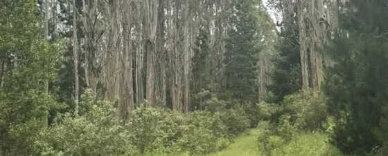
Toorongo Falls Car Camping, near Noojee
Toorongo Falls Reserve
10 Apr 2024 12:00 – 14 Apr 2024 16:00
Car-based camping in a free camping area at Toorongo Falls Campground, with day walks in the region. Attend from Wednesday (after lunch) to Sunday, or whichever days you can manage within that period.
There is a limit of 25 people for this event. Contact the leader if you want to be wait listed.
GRADE | LENGTH | TYPE: Varied day walks from a base camp at Toorongo Falls Campground.
ACTIVITY DESCRIPTION: This is a picturesque campsite in the bush. It is located inside the National Park. There are BBQs, fire pits, camp sites and toilets. We can light a fire (except during fire ban days). There is limited mobile phone coverage.
There are many picturesque day walks to do in the area.
You will need to be self sufficient. Drinking water is not available at the campsite but water can be used from the creek for washing and cooking.
BOOKING: By Sunday 7th April. To register, click on Get Tickets.
Unsure if you've already booked? Click View my bookings.
FURTHER INFORMATION: greatforestnationalpark.com.au/attraction/toorongo-falls-campground.
MEETING LOCATION: The campground is accessible with 2WD vehicles from Toorongo Falls Rd. Further details on how to get there will be provided to all registered attendees.
DISTANCE | TIME FROM GPO: Two hours drive (140 km) from Melbourne.
PUBLIC TRANSPORT: Not available. We will try to maximise car pooling.
MEALS: Bring all supplies, ample drinking water and camping equipment. There is no drinking water on the site, but the creek will be flowing for washing and cooking water.
ACCOMMODATION: Provide your own tent as there are no facilities.
APPAREL: It can be quite warm, or can rain. Come prepared after having a good look at the weather forecast.
COST: Camping is free.
LEADER: Roger H. | Email LeaderRogerH.thenomadsinc@mail.tidyhq.com if you have any questions.
Members can access leader contact details under Members | Leader Contacts when logged in to the website.
Image: Parks Victoria
HOME BACK TO LIST OF EVENTS MEMBERSHIPS
Apr
09
2024
Past Event
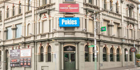
Monthly Social Night - Palace Hotel
Palace Hotel
19:00 – 21:00
Our regular monthly social night - this month at the Palace Hotel, Camberwell.
GRADE: Social.
ACTIVITY DESCRIPTION: Join us for our monthly social evening where members can enjoy a meal, talk about upcoming events, compare notes on past activities and float ideas on events they would like to see run. April is planning month, where we sketch out the program of events for the upcoming winter quarter. Most of the planning will have been done via a Zoom pre-planning meeting the previous night, but in this social evening we also welcome additional suggestions to fill any gaps. Do you want to see more of a particular activity, or do you have a particularly favourite area of Victoria you would like to share with others? Do you have an idea for a walk we haven't done before? If so, we'd love to hear from you. Everyone is welcome – you don't have to volunteer for an activity. New members are especially invited to any of the monthly Nomads social evenings.
See the Palace Hotel website for more details, including their reasonably priced menu.
BOOKING: By Sunday 7th April. To register, click on Get Tickets.
Unsure if you've already booked? Click View my bookings.
MEETING TIME | LOCATION: 7pm at the Palace Hotel, 893 Burke Rd, Camberwell.
MAP REFERENCE: Melway map 45 grid J11. Google map goo.gl/maps/crgZLRcfdTs2GPSN6.
PUBLIC TRANSPORT: The Palace Hotel is directly opposite Camberwell Station. Alternatively, catch tram 72 to stop 64 (Camberwell Station).
LEADER: Garry O. | Email LeaderGarryO.thenomadsinc@mail.tidyhq.com if you have any questions.
Members can access leader contact details under Members | Leader Contacts when logged in to the website.
HOME BACK TO LIST OF EVENTS MEMBERSHIPS

Apr
08
2024
Past Event
Winter Program Pre-planning - Online via Zoom
19:00 – 20:00
Preparing the draft Winter program of events - online via Zoom.
GRADE: Social.
ACTIVITY DESCRIPTION: The bulk of the planning for the upcoming Winter program will be done in this pre-planning meeting via Zoom in readiness to present the draft program the next night at the Social Evening, where attendees will be invited to provide additional suggestions and help fill any gaps.
BOOKING: By 5pm Monday 8th April. To register, click on Get Tickets. Alternatively, simply click on the Zoom link in the reminder email sent to members a few days prior to the event.
Unsure if you've already booked? Click View my bookings.
DRAFT PROGRAM: Nomads Draft Program. You may add your suggestions to this online spreadsheet - be sure to click to some other cell once you've finished, so that your suggestion gets saved.
MEETING TIME | LOCATION: 7pm online via Zoom. Those who registered will be sent the Zoom link by 6pm on Monday evening.
LEADER: Alan D. | Email LeaderAlanD.thenomadsinc@mail.tidyhq.com if you have any questions.
Members can access leader contact details under Members | Leader Contacts when logged in to the website.
Photo by Bich Tran from Pexels.
HOME BACK TO LIST OF EVENTS MEMBERSHIPS
Apr
07
2024
Past Event
Childers Plantation Loop Walk
Childers Settlement Road
11:00 – 16:00
A circuit walk south east of Melbourne. This is the first day after daylight saving ends so you can sleep in an hour..., but it is about a two hour drive
GRADE | LENGTH | TYPE: Easy-Moderate 8 km circuit walk.
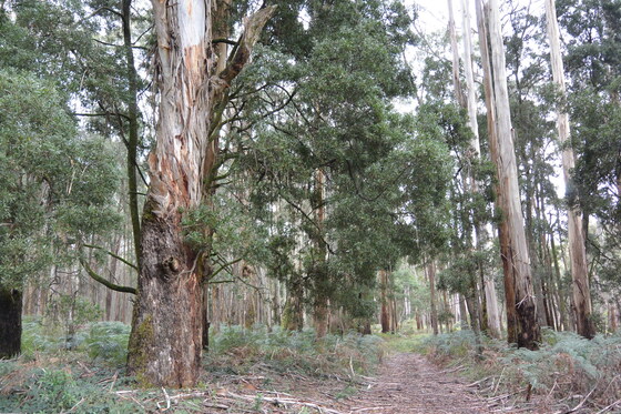
ACTIVITY DESCRIPTION: Childers Plantation Loop is a terrific walk through beautiful eucalypt forest near Yarragon South, Victoria. The path begins from Childers Settlement Road and winds through the plantations and its varied terrain. The forest makes way to green open rolling hills that offer a fantastic view of the surrounding farmland.
The track can get muddy after rain, so be sure to set out with good footwear if there's been recent rainfall.
BOOKING: By Friday 5th April. To register, click on Get Tickets.
Unsure if you've already booked? Click View my bookings.
MEETING TIME | LOCATION: 11am in Childers Settlement Rd, at the Loop Track junction 1 km south from Allambee-Childers Rd (see map). Note this is about a two-hour drive from Melbourne
PUBLIC TRANSPORT: Public transport is not feasible.
MAP REFERENCE: Melway map X912 V8 | Google map maps.app.goo.gl/JpbADjk3BEBdLN3y6
FOOD: Carry lunch, snacks and a litre of water.
APPAREL | FOOTWEAR: Comfortable walking boots and dress according to the weather forecast.
LEADER: Richard C. | Email LeaderRichardC.thenomadsinc@mail.tidyhq.com if you have any questions.
Members can access leader contact details under Members | Leader Contacts when logged in to the website.
HOME BACK TO LIST OF EVENTS MEMBERSHIPS
Mar
31
2024
Past Event
Cathedral Range: Ned's Gully Circuit Walk **EVENT CANCELLED
Cooks Mill Campground
10:30 – 15:30
** Unfortunately, this event has been cancelled due to an injury of the event leader **
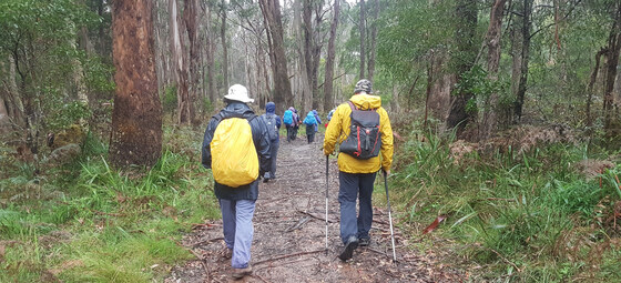
A classic walk in Taggerty starting with a warm-up then a steep climb, a high peak, a spectacular ridge walk, a gully descent and a river flat walk to complete the circuit in the Cathedral Range, a spectacular seven kilometre long ridge of sharply upturned sedimentary rock.
GRADE | LENGTH | TYPE: Hard grade (due to the steepness) 12 km circuit walk.
ACTIVITY DESCRIPTION: From Cooks Mill car park there is a warm-up walk for about 1 km up Cerebus Road, followed by a steep climb up a well marked track. Before reaching the top, turn north and head around a gully to another track junction. Follow the right hand track to detour to North Jawbone Peak. Return to the main track and continue north to the Cathedral Ridge. Follow the ridge to The Cathedral (Cathedral Peak) and then north again to Cathedral North, the highest point in the walk.
Return, and having passed The Cathedral again, find the steep rocky track east and down to Neds Saddle. Take care as this section can be slippery, especially in wet weather. Continue further east and up to Neds Peak, then on and down to rejoin Neds Gully Track. Down in the Little River flat and before the river, turn right at the Little River Walking Track and head upstream (south) to the start at Cooks Mill car park.
BOOKING: By Friday 29th March. To register click on Get Tickets.
Unsure if you've already booked? Click View my bookings.
FURTHER INFORMATION: Bushwalking Victoria: Neds Gully – Cathedral Peak – Neds Peak – Neds Gully and map.
MEETING TIME | LOCATION: 10:30am in the car park of Cooks Mill Campground, Little River Track, Rubicon.
MAP REFERENCE: Melway map X910 grid T10 | Google map goo.gl/maps/mBC4SXbNzUYoEdU5A.
DISTANCE | TIME FROM GPO: 122 km, approximately 2 hours 15 minutes via M3 and B360 (Black Spur Drive) to Taggerty, then Cathedral Lane and Little River Road to St Bernards Track.
FOOD: Carry lunch, snacks and a litre of water.
APPAREL | FOOTWEAR: Comfortable walking boots and dress according to the weather forecast. The weather can be more changeable in the Cathedral Ranges, so layers are advised.
LEADER: Subra N. | Email LeaderSubraN.thenomadsinc@mail.tidyhq.com if you have any questions.
Members can access leader contact details under Members | Leader Contacts when logged in to the website.
HOME BACK TO LIST OF EVENTS MEMBERSHIPS

Mar
29
2024
Past Event
A Good Friday Bike Ride: Boronia - Blind Ck - Dandenong Ck - Carrum
Boronia Station
10:30 – 17:00
Join the Nomads Friday cycling group on Good Friday. This will be quite a scenic ride, almost entirely off-road, following the Blind Creek and Dandenong Creek to Carrum (by which point the Dandenong Creek has been renamed to Patterson River).
GRADE | LENGTH | TYPE: Medium to Hard cycling tour of approximately 44 km, being 28 km to lunch, then a further 16 km to Carrum. One of the reasons for the Medium to Hard grading is that we'll be trying to get to the lunch spot before it becomes too crowded! It will be possible to exit at Dandenong Station (approximately 3 km after lunch). For the route, see Boronia - Blind Ck - Dandenong Ck - Carrum.
ACTIVITY DESCRIPTION: From Boronia Station we'll cycle along the trail beside the Belgrave train line to get to Blind Creek, then follow the Blind Creek Trail to where it joins the Eastlink Trail. From there, we follow the Eastlink and Dandenong Creek Trails to our lunch spot, the Dandenong Workers Club, 52-70 Wedge St, Dandenong, which is located right beside the cycling path. After lunch, we'll continue along the Dandenong Creek Trail to Carrum. It's going to be reasonably warm, so you can optionally enjoy a dip at the beautiful Carrum Beach prior to catching a train from Carrum Station. Whenever you're ready to head towards the CBD, trains depart from Carrum Station every 10 minutes. You could of course also ride home via the Bayside Trail if you want to get a really good workout!
BOOKING: By noon on Thursday 28th March so we can confirm our lunch booking. To register click on Get Tickets.
Unsure if you've already booked? Click View my bookings.
MEETING TIME | LOCATION: We'll plan to depart at 10.30am from the Boronia Train Station (the exit on the eastern side; i.e. turn left after leaving the train).
MAP REFERENCE: Melway map 64 grid K9 | Google map maps.app.goo.gl/1F2uiE6ZBk8VBdMm8.
WEATHER FORECAST: The forecast is for pleasant, but warm, conditions. The early forecast for Friday was "12 to 30 degrees. Sunny. Light winds becoming east to northeasterly 15 to 20 km/h during the morning.". For more details see the BOM Dandenong Detailed Forecast or the BOM MetEye.
PUBLIC TRANSPORT: Catch the Belgrave line train that departs from Flinders Street Station, platform 2, at 9:26am (or from Richmond at 9:39am), which should arrive at Boronia at 9:27am.
PRE-RIDE COFFEE: If you'd like a pre-ride coffee, you should catch the Lilydale line train that departs from Flinders Street, platform 3, at 9:06am (or from Richmond at 9:19am), then change in Ringwood to the 10am Belgrave train, which should arrive at Boronia at 10:09am. There's a cafe right opposite the station exit. However, you'll only have 2 minutes to cross the platform in Ringwood, to change from the Lilydale to the Belgrave service.
FOOD: Carry snacks if you wish and a litre of water. Lunch will be purchased at The Workers Club in Dandenong.
NOTE: The Workers Club is usually very quiet on Fridays, but on this occasion there will be bingo starting at 1pm and live music from 3pm. We plan to arrive there before 12:45pm. We'll be sitting outside, so shouldn't be impacted too much, except that it will be much busier than normal. They also have a special Good Friday set lunch menu, but that needs to be pre-paid and won't suit some members of our group, so I've elected for us to dine from their normal bistro menu.
APPAREL | FOOTWEAR: Comfortable attire for the weather forecast, in addition to your bike and helmet. A spare bike tube is advisable.
LEADER: Alan D. | Email LeaderAlanD.thenomadsinc@mail.tidyhq.com if you have any questions.
Members can access leader contact details under Members | Leader Contacts when logged in to the website.
HOME BACK TO LIST OF EVENTS MEMBERSHIPS
Mar
29
2024
Past Event
Tantawangalo Easter weekend NSW Naturist camp
1466 Tantawangalo Mountain Rd
29 Mar 2024 10:00 – 01 Apr 2024 17:00
Tantawangalo is located in the south western part of the Bega Valley. You are invited to stay on a private property that abuts the South East Forest National Park. The Tantawangalo Creek runs through the property which provides a few good swimming holes in this granite country forest.
GRADE | LENGTH | TYPE: Easy to Moderate and maybe Hard if we do some of the 4WD track walks, but the grading depends on the activities we choose to do.
ACTIVITY DESCRIPTION: Camp around the house and have access to a BBQ, kitchen, shower, toilet and outside bath or camp down towards the creek with access to creek water and a pit loo. Depending on the group and the weather, we can go and visit a number of local beaches, one nudist. Other options are exploring the private property and its swimming holes, a walk to the town water weir on the Tantawangalo Creek or walking a number of 4WD tracks in the National Park, or just lazing around.
BOOKING: By Friday 22nd March. To register click on Get Tickets.
Unsure if you've already booked? Click View my bookings.
MEETING TIME | LOCATION: Arrival time is flexible. The address is 1466 Tantawangalo Mountain Road, Tantawangalo NSW.
MAP REFERENCE: Google map maps.app.goo.gl/DaVdwpJ88u5CoGF1A.
DISTANCE | TIME FROM GPO: 573 km, approximately 7 hours via Monash Fwy/M1 and the Princes Hwy A1 to Cann River, through Bombala and on to Bega. There is 15 km of dirt road to reach the property through National Park. You can go via Eden, Pambula and Candelo but this will take longer and only has 5 km of dirt road. It may be preferable to come part way on the Thursday night and camp at the Caravan park in Bruthen, for which booking ASAP is recommended. Please don’t travel in the dark as there tends to be many animals around.
PUBLIC TRANSPORT: The leader will attempt to organise car pooling, as public transport is troublesome, though public transport is possible if a pick-up/drop-off in Bega can be arranged.
Outbound: Catch the V/line Bairnsdale service departing from Southern Cross at 7:17am on Thursday 28 March, connecting with a coach that arrives in Bega at 4:50pm. Total travel time 9 hours and 35 minutes at a cost of $35.20 full or $17.60 concession/seniors.
Return: The return service departs from Bega at 6:50am (on 2 April) to connect with a train departing from Bairnsdale at 12:54pm, which arrives at Southern Cross at 4:44pm. Total journey time 9 hours 54 minutes at a cost of $35.20 full or $17.60 concession/seniors.
WHAT TO BRING: Camping gear, food, drinks and what you expect to use for the long weekend.
APPAREL | FOOTWEAR: Comfortable walking boots/shoes, sunscreen and dress according to the weather forecast for the Bega area. Bega’s weather usually arrives a day after what Melbourne had, but not necessarily, as Bega is on the east (Pacific) coast.
LEADER: Les B. | Email LeaderLesB.thenomadsinc@mail.tidyhq.com if you have any questions.
Members can access leader contact details under Members | Leader Contacts when logged in to the website.
HOME BACK TO LIST OF EVENTS MEMBERSHIPS
Mar
24
2024
Past Event
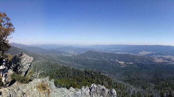
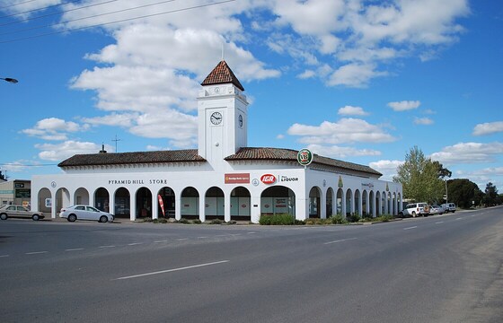
Mounting Pyramid Hill
Southern Cross
07:30 – 21:15
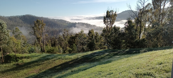
Enjoy stunning Victorian Autumnal weather on the penultimate 2023-2024 daylight saving Sunday. Enjoy 360 degree views of the northern plains from the top of Pyramid Hill. This day-trip has been designed to use public transport.
Note #1: this trip is only possible on a Sunday via the train timetable
Note #2: the event will be postponed in the event of train replacement buses in operation
GRADE | LENGTH | TYPE: Easy to medium, approximately 8 km, circuit walk on flat paths plus the ascent to and the descent from the "Hill".
ACTIVITY DESCRIPTION: Pyramid is a small town of 600 people about an hour north-west of Bendigo. The area was surveyed in 1836 by Major Thomas Mitchell during his journey into "Australia Felix". The granite "Hill" at 187 metres above sea level reminded Major Mitchell of the monuments of Egypt.
Upon arrival at Pyramid Station there will be a 3 km walk to the "Hill" Summit park. This will be the lunch spot with ample time to both undertake the walk around the Summit plus scramble up and down the Summit.
Time and interest permitting, on the return journey there is the opportunity to deviate via the nearby Pyramid Bushland Reserve. The local bakery plus the Pub should be open for refreshments before starting the return train journey at 5:47pm
BOOKING: By Thursday 21st March. To register, click on Get Tickets.
Unsure if you've already booked? Click View my bookings.
MEETING TIME | LOCATION: 07:30am at Southern Cross Station to board the 07:40am train to Swan Hill. Travel options are (1) by train (see details below) or (2) driving and parking at Pyramid Station by 11:05am.
MAP REFERENCES:
Southern Cross Station - Melway map 1A grid A7 | Google map goo.gl/maps/s6DUsRG8CWz2K97eA
Pyramid Station - Melway map 621 grid C5 | Google map maps.app.goo.gl/axwKJmwBW4SB7eY87
DISTANCE | TIME FROM GPO: 248 km, approximately 2 hours 55 minutes to drive, 3 hours 29 minutes by public transport.
PUBLIC TRANSPORT: The trip starts on the train departing Southern Cross Station at 07:40am arriving at Pyramid at 11:09am. It's suggested that we gather in the first carriage (North Melbourne end) which has unreserved seating. The return train departs Pyramid at 5:47pm arriving back at Southern Cross at 9:12pm. Day return weekend fares are capped at $7.20 (Full) and $3.60 (Concession & Seniors).
Note #3 - paper tickets are required for this day-return trip. Advance purchase or buy on arrival at Southern Cross. To enable the group to travel together, travel will be in an unreserved carriage.
FOOD: BYO lunch and snacks plus a refillable water container. The local bakery and store will both be open BUT the availabilty of pre-prepared meals is unknown (it's a self-sufficient country town).
APPAREL | FOOTWEAR: Comfortable walking shoes and dress according to the weather forecast.
FURTHER INFORMATION: V/Line Swan Hill Timetables; Pyramid Hill Summit Walk; Welcome to Pyramid Hill
LEADER: Garry Oliver | Email LeaderGarryO.thenomadsinc@mail.tidyhq.com if you have any questions.
Members can access leader contact details under Members | Leader Contacts when logged in to the website.
HOME | BACK TO LIST OF EVENTS | MEMBERSHIPS
Mar
17
2024
Past Event
Radio Springs Hotel - Babbington Hill Walk
Radio Springs Hotel Bed & Breakfast
11:00 – 14:30
A climb near Babbington Hill in the Wombat State Forest, passing by a beautiful reservoir and an historic mineral spring. Refreshments back at the starting point at Lyonville's Radio Springs Hotel.
GRADE | LENGTH | TYPE: Moderate 9.7 km circuit walk.
ACTIVITY DESCRIPTION: This scenic walk highlights some of the interesting history of Lyonville, located in the Daylesford Spa Country. Starting at the Radio Springs Hotel we pass through the local settlement and farmland that gives way to the densely treed Wombat State Forest, The area originally attracted James Lyon, after whom the town is named, and who built large sawmills in the region. We pass by the Bullarto Reservoir then circuit near the Babbington Hill (822m) before descending to the historic Lyonville Spring for lunch with its mineral waters. From the mineral springs we walk along the old tramway route that parallels the Loddon River. The walk will end at the starting point, Radio Springs Hotel, where we can have afternoon refreshments afterwards.
BOOKING: By Friday 15th March. To register click on Get Tickets.
Unsure if you've already booked? Click View my bookings.
MEETING TIME | LOCATION: 11am in the car park of the Radio Springs Hotel, 1 High St, Lyonville.
MAP REFERENCE: Melway map X909 grid D10 | Google map maps.app.goo.gl/mffYVKSy9GGzc5ou7.
DISTANCE | TIME FROM GPO: 102 km, approximately 1 hour 15 minutes via Calder Fwy/M79 to Woodend, then follow directions to Daylesford, taking the Tylden-Woodend Rd, then the C318 Kyneton-Trentham Rd, and finally the C317 Trentham-Daylesford Rd to Lyonville.
PUBLIC TRANSPORT: Take the 9:06am Echuca train from Southern Cross to Woodend, then transfer to the Daylesford coach service, arriving at Main St/Daylesford-Trentham Rd, Lyonville at 10:46am.
FOOD: Carry lunch, snacks and a litre of water.
APPAREL | FOOTWEAR: Comfortable walking boots/shoes and dress according to the weather forecast. Lyonville can be several degrees cooler than Melbourne.
LEADER: Robert H. | Email LeaderRobertH.thenomadsinc@mail.tidyhq.com if you have any questions.
Members can access leader contact details under Members | Leader Contacts when logged in to the website.
HOME BACK TO LIST OF EVENTS MEMBERSHIPS
Mar
11
2024
Past Event
Trentham Circuit Walk via the Domino Trail
10:00 – 17:00
Finish off your long weekend with a scenic walk along the Domino Rail Trail and Blighs Rd, on your way back to Melbourne.
GRADE | LENGTH | TYPE: Moderate 9 km circuit walk. This is mostly flat, though there will be some short scrambles around the Domino Creek region. Some sections could be muddy and slippery if there has been recent rain.
ACTIVITY DESCRIPTION: This walk is designed as a scenic diversion to enjoy on your way back to Melbourne after the ChillOut weekend, but can equally be appreciated as a day walk from Melbourne on the Labour Day Monday. From the starting point in Trentham, we'll head directly to the Domino Trail, which follows part of the former railway line between Daylesford and Carlsruhe. This circuit won't simply be an out-and-back walk though, as there will be variations between the out and back route, in particular to follow Blighs Rd in one direction.
BOOKING: By Saturday 9th March. To register click on Get Tickets.
Unsure if you've already booked? Click View my bookings.
FURTHER INFORMATION: Associated Nomads activities during the ChillOut Festival:
Friday to Monday: The Nomads Labour Day Long Weekend – ChillOut Camping.
Saturday 10am: The Nomads ChillOut Saturday Morning Community Walk.
Sunday: Attend the ChillOut Festival Street Parade then either head to the ChillOut Carnivale, attend the Naturist Walk, relax at the camp or attend any of the other events around town.
Sunday 1:30pm: The Nomads Daylesford Naturist Walk during ChillOut.
Sunday evening: We'll once again organise an evening meal at the Spice of India Restaurant, within easy walking distance of the Jubilee Lake Holiday Park.
MEETING TIME | LOCATION: 11am at the Quarry Street Recreation Reserve, located on Quarry St between Albert St and Victoria St, Trentham. There are public toilets at the meeting point.
MAP REFERENCE: Melway map X909 grid E10 | Google map maps.app.goo.gl/hxafR5BhFnGbzGtD8 | FedWalks 2023 Walk 2 Domino Trail and Return.
DISTANCE | TIME FROM GPO: 93 km, between 75 and 90 minutes to drive via the M79 Calder Fwy. Parking is available in Quarry St, on the north and the south side of its intersection with High Street (the main Trentham throughfare and just downhill from the Cosmopolitan Hotel).
PUBLIC TRANSPORT: Public transport options are available via train between Southern Cross station and Woodend (or Kyneton), plus a bus to Trentham. Myki cannot be used on the Daylesford bus service - tickets should be purchased online in advance. Recommended options:
Getting There: From Southern Cross, catch the 9:06am Echuca service and alight at Woodend at 10:04am. Transfer to the Daylesford bus service that departs from Woodend at 10:14am and arrives at Trentham Milk Bar/Market St at 10:36am. The bus stop is about 300 metres from the meeting point - from the bus stop head north, then turn left into High St (C318). Turn right (into Quarry St) at the second High St intersection.
Return: Catch the Daylesford-Woodend bus service from Trentham Milk Bar/Market St, Trentham at 2:39pm, which has a connection at Woodend that should have you arriving at Southern Cross at 4:24pm. It's expected that the walk will finish in time for you to catch this service.
FOOD: Carry lunch, snacks and a litre of water. There are excellent options in Trentham, such as the RedBeard Bakery, for purchasing your lunch.
APPAREL | FOOTWEAR: Comfortable walking boots/shoes and dress according to the weather forecast. Trentham is at 700 metres elevation, so it's likely to be cooler and wetter than Melbourne and the trails may be muddy.
LEADER: Alan D. | Email LeaderAlanD.thenomadsinc@mail.tidyhq.com if you have any questions.
Members can access leader contact details under Members | Leader Contacts when logged in to the website.
HOME BACK TO LIST OF EVENTS MEMBERSHIPS